Anju, South Pyongan
Anju
안주 | |
|---|---|
| Korean transcription(s) | |
| • Chosŏn'gŭl | 안주 |
| • Hancha | 安州 |
| • McCune-Reischauer | Anju |
| • Revised Romanization | Anju |
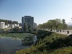 View of Anju | |
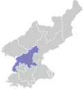
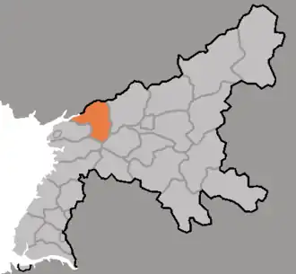 Map of South Pyongan showing the location of Anju | |
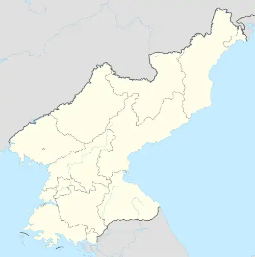 Anju Location within North Korea | |
| Coordinates: 39°37′12″N 125°39′36″E / 39.62000°N 125.66000°E | |
| Country | North Korea |
| Province | South P'yongan |
| Administrative divisions | 20 tong, 22 ri |
| Population (2008[1]) | |
• Total | 240,117 |
| • Dialect | P'yŏngan |
| Time zone | UTC+9 (Pyongyang Time) |
Anju (Korean: 안주; Korean pronunciation: [an.dzu]) is a city in South Pyongan Province, North Korea. Its population was 240,117 in 2008.[1] The Ch'ongch'on River passes through Anju.
Climate
| Climate data for Anju, South Pyongan (1991–2020) | |||||||||||||
|---|---|---|---|---|---|---|---|---|---|---|---|---|---|
| Month | Jan | Feb | Mar | Apr | May | Jun | Jul | Aug | Sep | Oct | Nov | Dec | Year |
| Mean daily maximum °C (°F) | −1.1 (30.0) |
2.4 (36.3) |
8.8 (47.8) |
16.4 (61.5) |
22.2 (72.0) |
26.3 (79.3) |
28.3 (82.9) |
29.1 (84.4) |
25.4 (77.7) |
18.5 (65.3) |
9.0 (48.2) |
0.5 (32.9) |
15.5 (59.9) |
| Daily mean °C (°F) | −6.5 (20.3) |
−2.9 (26.8) |
3.2 (37.8) |
10.3 (50.5) |
16.3 (61.3) |
21.1 (70.0) |
24.2 (75.6) |
24.5 (76.1) |
19.4 (66.9) |
12.1 (53.8) |
3.9 (39.0) |
−4.1 (24.6) |
10.1 (50.2) |
| Mean daily minimum °C (°F) | −11.5 (11.3) |
−7.7 (18.1) |
−1.5 (29.3) |
4.6 (40.3) |
10.8 (51.4) |
16.5 (61.7) |
20.7 (69.3) |
20.7 (69.3) |
14.5 (58.1) |
6.6 (43.9) |
−0.6 (30.9) |
−8.2 (17.2) |
5.4 (41.7) |
| Average precipitation mm (inches) | 7.8 (0.31) |
15.2 (0.60) |
20.9 (0.82) |
48.8 (1.92) |
78.8 (3.10) |
97.8 (3.85) |
292.8 (11.53) |
243.8 (9.60) |
100.3 (3.95) |
50.1 (1.97) |
46.0 (1.81) |
15.4 (0.61) |
1,017.7 (40.07) |
| Average precipitation days (≥ 0.1 mm) | 2.9 | 3.2 | 3.7 | 5.7 | 7.5 | 8.0 | 12.0 | 10.0 | 6.0 | 5.5 | 6.4 | 5.1 | 76.0 |
| Average snowy days | 3.9 | 2.7 | 1.6 | 0.1 | 0.0 | 0.0 | 0.0 | 0.0 | 0.0 | 0.1 | 1.3 | 4.7 | 14.4 |
| Average relative humidity (%) | 70.8 | 67.7 | 67.3 | 66.1 | 70.8 | 76.4 | 82.8 | 82.0 | 76.2 | 72.4 | 72.4 | 71.2 | 73.0 |
| Source: Korea Meteorological Administration[2] | |||||||||||||
Administrative divisions
Anju-si is divided into 20 tong (neighbourhoods) and 22 ri (villages):
|
|
Economy
Anju lies near large deposits of anthracite coal, and contains one of the largest coal production facilities in the country.[3] The deposits contain more than 130 million metric tons of coal.[4] Namhŭng-dong is the location of the Namhŭng Youth Chemical Complex, one of North Korea's most important chemical combines.[5] Anju also contains at least one hotel open for foreigners, used primarily to accommodate for more travelers during peak holiday times.[6]
Anju is the location of the Cemetery for Martyrs of the Chinese People's Volunteers, commemorating Korean War dead.
Transportation
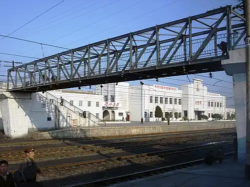
Anju-si is served by several stations on the P'yŏngŭi and Kaech'ŏn lines of the Korean State Railway.
Anju has a trolleybus system with one line to Sinanju Chongnyon station. It formerly had another line to Namhung Youth Chemical Complex that looped around the entire complex which closed around 2000.[7]
See also
References
- ^ a b North Korean Central Statistic Bureau, 2008 Census Archived 2010-03-31 at the Wayback Machine.
- ^ "30 years report of Meteorological Observations in North Korea (1991 ~ 2020)" (PDF) (in Korean). Korea Meteorological Administration. pp. 214, 306, and 344. Archived (PDF) from the original on 29 January 2022. Retrieved 24 March 2022.
- ^ North Korea Handbook. M.E. Sharpe. 2003. ISBN 0765610043. Retrieved 2012-07-18.
- ^ Kuo, Chin S. (1994). "The mineral industry of North Korea" (PDF). Archived from the original (PDF) on 2004-10-30. Retrieved 2012-07-18.
- ^ Joseph S. Bermudez Jr. (10 April 2014). "North Korea's Namhung Youth Chemical Complex: Seven Years of Construction Pays Off". US-Korea Institute at SAIS.
- ^ Gareth Johnson (20 December 2019). "Anju County, North Korea". Young Pioneer Tours.
- ^ "Anju". transphoto.org. Retrieved 2021-01-02.
Further reading
- Dormels, Rainer. North Korea's Cities: Industrial facilities, internal structures and typification. Jimoondang, 2014. ISBN 978-89-6297-167-5
External links
- City profile of Anju Archived 2016-03-09 at the Wayback Machine
| 2,000,000 and more |
|
|---|---|
| 1,000,000–1,999,999 |
|
| 500,000–999,999 | |
| 200,000–499,999 | |