Pyongwon County
P'yŏngwŏn County
평원군 | |
|---|---|
| Korean transcription(s) | |
| • Chosŏn'gŭl | 평원군 |
| • Hancha | 平原郡 |
| • McCune-Reischauer | P'yŏngwŏn-gun |
| • Revised Romanization | Pyeongwon-gun |
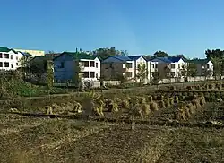 Village in Pyongwon County. | |
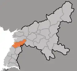 Map of South Pyongan showing the location of Pyongwon | |
| Country | North Korea |
| Province | South P'yŏngan |
| Administrative divisions | 1 ŭp, 2 workers' districts, 29 ri |
| Area | |
• Total | 451.53 km2 (174.34 sq mi) |
| Population (2008[1]) | |
• Total | 179,492 |
| • Density | 400/km2 (1,000/sq mi) |
P'yŏngwŏn County is a kun (county) in South P'yŏngan province, North Korea.
Administrative divisions
P'yŏngwŏn County is divided into 1 ŭp (town), 2 rodongjagu (workers' districts) and 29 ri (villages):
|
|
Transportation
P'yŏngwŏn County is served by the P'yŏngŭi Line of the Korean State Railway.
References
- ^ Korean Central Bureau of Statistics: 2008 Population Census (Population 2008, published in 2009)
External links
- (in English) Map of Pyongan provinces Archived 2012-03-11 at the Wayback Machine
- (in Korean) Detailed map