Zenith, Kansas
Zenith, Kansas | |
|---|---|
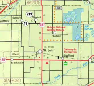 KDOT map of Stafford County (legend) | |
 Zenith  Zenith | |
| Coordinates: 37°57′26″N 98°29′31″W / 37.9572°N 98.4920°W[1] | |
| Country | United States |
| State | Kansas |
| County | Stafford |
| Elevation | 1,805 ft (550 m) |
| Time zone | UTC-6 (CST) |
| • Summer (DST) | UTC-5 (CDT) |
| Area code | 620 |
| FIPS code | 20-80950 [1] |
| GNIS ID | 473601 [1] |
Zenith is an unincorporated community in Stafford County, Kansas, United States.[1] It is located east of Stafford, next to a railroad and U.S. Route 50 highway at NE 140th Ave.
History
A post office was opened in Zenith in 1902, and remained in operation until it was discontinued in 1974.[2]
References
- ^ a b c d e "Aulne, Kansas", Geographic Names Information System, United States Geological Survey, United States Department of the Interior
- ^ "Kansas Post Offices, 1828-1961". Kansas Historical Society. Retrieved 23 June 2014.
Further reading
External links
Wikimedia Commons has media related to Stafford County, Kansas.
- Stafford County maps: Current, Historic Archived 2024-02-24 at the Wayback Machine, KDOT
Municipalities and communities of Stafford County, Kansas, United States | ||
|---|---|---|
| Cities | 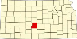 | |
| Unincorporated communities | ||
| Townships |
| |