Zbrašín
Zbrašín | |
|---|---|
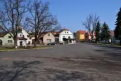 Centre of Zbrašín | |
 Flag  Coat of arms | |
 Zbrašín Location in the Czech Republic | |
| Coordinates: 50°17′58″N 13°45′58″E / 50.29944°N 13.76611°E | |
| Country | |
| Region | Ústí nad Labem |
| District | Louny |
| First mentioned | 1358 |
| Area | |
• Total | 12.75 km2 (4.92 sq mi) |
| Elevation | 303 m (994 ft) |
| Population (2025-01-01)[1] | |
• Total | 407 |
| • Density | 32/km2 (83/sq mi) |
| Time zone | UTC+1 (CET) |
| • Summer (DST) | UTC+2 (CEST) |
| Postal code | 440 01 |
| Website | www |
Zbrašín is a municipality and village in Louny District in the Ústí nad Labem Region of the Czech Republic. It has about 400 inhabitants.
Zbrašín lies approximately 8 kilometres (5 mi) south of Louny, 45 km (28 mi) south-west of Ústí nad Labem, and 53 km (33 mi) north-west of Prague.
Administrative division
Zbrašín consists of three municipal parts (in brackets population according to the 2021 census):[2]
- Zbrašín (178)
- Hořany (115)
- Senkov (102)
Demographics
| Year | Pop. | ±% |
|---|---|---|
| 1869 | 715 | — |
| 1880 | 755 | +5.6% |
| 1890 | 854 | +13.1% |
| 1900 | 874 | +2.3% |
| 1910 | 866 | −0.9% |
| 1921 | 902 | +4.2% |
| 1930 | 843 | −6.5% |
| 1950 | 557 | −33.9% |
| 1961 | 514 | −7.7% |
| 1970 | 450 | −12.5% |
| 1980 | 350 | −22.2% |
| 1991 | 287 | −18.0% |
| 2001 | 305 | +6.3% |
| 2011 | 309 | +1.3% |
| 2021 | 395 | +27.8% |
| Source: Censuses[3][4] | ||
References
- ^ "Population of Municipalities – 1 January 2025". Czech Statistical Office. 2025-05-16.
- ^ "Public Census 2021 – basic data". Public Database (in Czech). Czech Statistical Office. 2022.
- ^ "Historický lexikon obcí České republiky 1869–2011" (in Czech). Czech Statistical Office. 2015-12-21.
- ^ "Population Census 2021: Population by sex". Public Database. Czech Statistical Office. 2021-03-27.
External links
Wikimedia Commons has media related to Zbrašín.