Zádub-Závišín
Zádub-Závišín | |
|---|---|
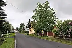 Main street | |
 Flag  Coat of arms | |
 Zádub-Závišín Location in the Czech Republic | |
| Coordinates: 49°58′16″N 12°44′36″E / 49.97111°N 12.74333°E | |
| Country | |
| Region | Karlovy Vary |
| District | Cheb |
| First mentioned | 1273 |
| Area | |
• Total | 6.33 km2 (2.44 sq mi) |
| Elevation | 760 m (2,490 ft) |
| Population (2025-01-01)[1] | |
• Total | 495 |
| • Density | 78/km2 (200/sq mi) |
| Time zone | UTC+1 (CET) |
| • Summer (DST) | UTC+2 (CEST) |
| Postal code | 353 01 |
| Website | www |
Zádub-Závišín (German: Hohendorf-Abaschin) is a municipality in Cheb District in the Karlovy Vary Region of the Czech Republic. It has about 500 inhabitants.
Administrative division
Zádub-Závišín consists of three municipal parts (in brackets population according to the 2021 census):[2]
- Zádub (196)
- Závišín (89)
- Milhostov (46)
Demographics
| Year | Pop. | ±% |
|---|---|---|
| 1869 | 599 | — |
| 1880 | 737 | +23.0% |
| 1890 | 814 | +10.4% |
| 1900 | 897 | +10.2% |
| 1910 | 1,114 | +24.2% |
| 1921 | 949 | −14.8% |
| 1930 | 1,052 | +10.9% |
| 1950 | 515 | −51.0% |
| 1961 | 413 | −19.8% |
| 1970 | 328 | −20.6% |
| 1980 | 277 | −15.5% |
| 1991 | 257 | −7.2% |
| 2001 | 263 | +2.3% |
| 2011 | 308 | +17.1% |
| 2021 | 331 | +7.5% |
| Source: Censuses[3][4] | ||
References
- ^ "Population of Municipalities – 1 January 2025". Czech Statistical Office. 2025-05-16.
- ^ "Public Census 2021 – basic data". Public Database (in Czech). Czech Statistical Office. 2022.
- ^ "Historický lexikon obcí České republiky 1869–2011" (in Czech). Czech Statistical Office. 2015-12-21.
- ^ "Population Census 2021: Population by sex". Public Database. Czech Statistical Office. 2021-03-27.
External links
Wikimedia Commons has media related to Zádub-Závišín.