Wustrower Dumme
| Wustrower Dumme | |
|---|---|
 | |
| Location | |
| Country | Germany |
| States | |
| Physical characteristics | |
| Source | |
| • location | at the Gielau Mill near Schnega |
| • coordinates | 52°51′44″N 10°51′18″E / 52.8622917°N 10.8550694°E |
| • elevation | ca. 41 m (135 ft) |
| Mouth | |
• location | near Wustrow into the Jeetzel |
• coordinates | 52°55′46″N 11°07′32″E / 52.929375°N 11.12556°E |
• elevation | ca. 17 m (56 ft) |
| Length | 32.5 km (20.2 mi)[1] |
| Basin size | 275 km (171 mi) [1] |
| Basin features | |
| Progression | Jeetzel→ Elbe→ North Sea |
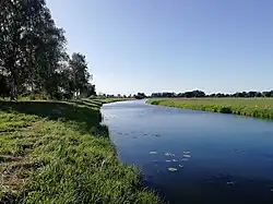
Wustrower Dumme is a river of the German states Saxony-Anhalt and Lower Saxony. It is a roughly 32 kilometres (20 mi) long, and a left, western tributary of the Jeetzel (also: Jeetze).
Course
The Dumme runs through the border region between Altmark in the south and Wendland in the north; in places it forms the border river between Lower Saxony and Saxony-Anhalt. During its course it passes Bergen an der Dumme, before discharging into the northward-flowing Jeetzel near Wustrow, hence the first part of the name.
See also
References