Wolf Summit, West Virginia
Wolf Summit, West Virginia | |
|---|---|
 Wolf Summit  Wolf Summit | |
| Coordinates: 39°16′51″N 80°27′39″W / 39.28083°N 80.46083°W | |
| Country | United States |
| State | West Virginia |
| County | Harrison |
| Area | |
• Total | 0.364 sq mi (0.94 km2) |
| • Land | 0.364 sq mi (0.94 km2) |
| • Water | 0 sq mi (0 km2) |
| Elevation | 1,119 ft (341 m) |
| Population (2020) | |
• Total | 214 |
| • Density | 590/sq mi (230/km2) |
| Time zone | UTC-5 (Eastern (EST)) |
| • Summer (DST) | UTC-4 (EDT) |
| Area codes | 304 & 681 |
| GNIS feature ID | 1556016[2] |
Wolf Summit is a census-designated place and coal town in Harrison County, West Virginia, United States. Its population was 214 at the 2020 census (down from 272 at the 2010 census).[3][4]
The community was named after the surname Wolf and its being the highest point on the railroad between Grafton and Parkersburg.[5]
References
- ^ "US Gazetteer files: 2010, 2000, and 1990". United States Census Bureau. February 12, 2011. Retrieved April 23, 2011.
- ^ U.S. Geological Survey Geographic Names Information System: Wolf Summit, West Virginia
- ^ "Census Bureau profile: Wolf Summit CDP, West Virginia". United States Census Bureau. May 2023. Retrieved May 25, 2025.
- ^ "U.S. Census website". United States Census Bureau. Retrieved May 14, 2011.
- ^ Kenny, Hamill (1945). West Virginia Place Names: Their Origin and Meaning, Including the Nomenclature of the Streams and Mountains. Piedmont, WV: The Place Name Press. p. 689.
Municipalities and communities of Harrison County, West Virginia, United States | ||
|---|---|---|
| Cities | 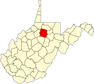 | |
| Towns | ||
| CDPs | ||
| Unincorporated communities |
| |