Windmill, New Mexico
Windmill, New Mexico | |
|---|---|
 Windmill  Windmill | |
| Coordinates: 31°58′39″N 108°37′35″W / 31.97750°N 108.62639°W | |
| Country | United States |
| State | New Mexico |
| County | Hidalgo |
| Area | |
• Total | 1.45 sq mi (3.74 km2) |
| • Land | 1.45 sq mi (3.74 km2) |
| • Water | 0.00 sq mi (0.00 km2) |
| Elevation | 4,364 ft (1,330 m) |
| Population | |
• Total | 54 |
| • Density | 37.34/sq mi (14.42/km2) |
| Time zone | UTC-7 (Mountain (MST)) |
| • Summer (DST) | UTC-6 (MDT) |
| Area code | 575 |
| GNIS feature ID | 2584239[2] |
Windmill is a census-designated place in Hidalgo County, New Mexico, United States. Its population was 43 as of the 2010 census.[4] The community is located along New Mexico State Road 9.
The community was founded in the 1970s. While it is located on a windy plain, as of 1991 it did not have a windmill despite its name.[5]
Geography
According to the U.S. Census Bureau, the community has an area of 1.446 square miles (3.75 km2), all land.[4]
Demographics
| Census | Pop. | Note | %± |
|---|---|---|---|
| 2020 | 54 | — | |
| U.S. Decennial Census[6][3] | |||
References
- ^ "ArcGIS REST Services Directory". United States Census Bureau. Retrieved October 12, 2022.
- ^ a b U.S. Geological Survey Geographic Names Information System: Windmill, New Mexico
- ^ a b "Census Population API". United States Census Bureau. Retrieved October 12, 2022.
- ^ a b "2010 Census Gazetteer Files - Places: New Mexico". U.S. Census Bureau. Retrieved August 21, 2014.
- ^ Julyan, Robert Hixson (January 1, 1996). The Place Names of New Mexico. UNM Press. p. 380. ISBN 9780826316899.
- ^ "Census of Population and Housing". Census.gov. Retrieved June 4, 2016.
Municipalities and communities of Hidalgo County, New Mexico, United States | ||
|---|---|---|
| City | 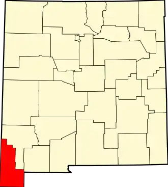 | |
| Village | ||
| CDPs | ||
| Other communities | ||
| Ghost towns | ||