West Adams, North Dakota
West Adams, North Dakota | |
|---|---|
Unorganized territory | |
 West Adams | |
| Coordinates: 46°12′01″N 102°55′59″W / 46.20028°N 102.93306°W | |
| Country | United States |
| State | North Dakota |
| County | Adams |
| Area | |
• Total | 67.0 sq mi (173.4 km2) |
| • Land | 66.9 sq mi (173.2 km2) |
| • Water | 0.08 sq mi (0.2 km2) |
| Elevation | 2,831 ft (863 m) |
| Population (2010) | |
• Total | 34 |
| • Density | 0.5/sq mi (0.2/km2) |
| Time zone | UTC-6 (Central (CST)) |
| • Summer (DST) | UTC-5 (CDT) |
| Area code | 701 |
| GNIS feature ID | 1036002[1] |
West Adams is an unorganized territory in Adams County, North Dakota, United States. As of the 2010 census it had a population of 34.[2] West Adams comprises the territory of the former townships of Lemmon and Whetstone.
References
- ^ U.S. Geological Survey Geographic Names Information System: West Adams, North Dakota
- ^ "Geographic Identifiers: 2010 Demographic Profile Data (G001): West Adams UT, Adams County, North Dakota". U.S. Census Bureau, American Factfinder. Archived from the original on February 12, 2020. Retrieved July 3, 2013.
Municipalities and communities of Adams County, North Dakota, United States | ||
|---|---|---|
| Cities | 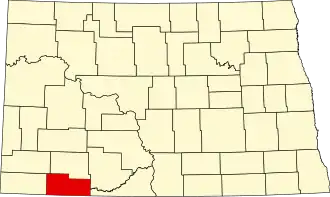 | |
| Townships | ||
| Unorganized territories | ||
| Unincorporated communities | ||