Walnut Township, Fremont County, Iowa
Walnut Township | |
|---|---|
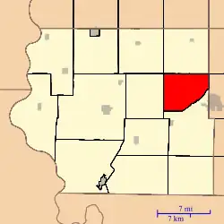 Location in Fremont County | |
| Coordinates: 40°46′59″N 95°26′56″W / 40.78306°N 95.44889°W | |
| Country | United States |
| State | Iowa |
| County | Fremont |
| Area | |
• Total | 25.2 sq mi (65.26 km2) |
| • Land | 25.2 sq mi (65.26 km2) |
| • Water | 0 sq mi (0 km2) 0% |
| Elevation | 1,109 ft (338 m) |
| Population | |
• Total | 145 |
| • Density | 5.8/sq mi (2.2/km2) |
| Time zone | UTC-6 (CST) |
| • Summer (DST) | UTC-5 (CDT) |
| ZIP codes | 51601, 51639 |
| GNIS feature ID | 0468884[2] |
Walnut Township is one of thirteen townships in Fremont County, Iowa, United States. As of the 2010 census, its population was 145 and it contained 66 housing units.[1]
Geography
As of the 2010 census, Walnut Township covered an area of 25.2 square miles (65 km2), all land.[1]
Transportation
School districts
- Farragut Community School District
- Shenandoah Community School District
Political districts
- Iowa's 3rd congressional district
- State House District 23
- State Senate District 12
References
- "TIGER/Line Shapefiles". United States Census Bureau.
- ^ a b c "2010 Census Gazetteer". United States Census Bureau. Retrieved February 23, 2014.
- ^ "Walnut Township, Fremont County, Iowa". Geographic Names Information System. United States Geological Survey, United States Department of the Interior. Retrieved February 23, 2014.
External links
Places adjacent to Walnut Township, Fremont County, Iowa | |
|---|---|
Municipalities and communities of Fremont County, Iowa, United States | ||
|---|---|---|
| Cities | 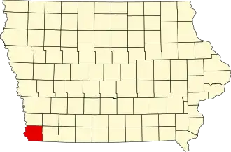 | |
| Townships | ||
| CDPs | ||
| Other unincorporated community | ||
| Footnotes | ‡This populated place also has portions in an adjacent county or counties | |