Walnut Township, Butler County, Kansas
Walnut Township Butler County, Kansas | |
|---|---|
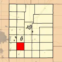 Location within Butler County | |
 Walnut Township Location within Kansas | |
| Coordinates: 37°36′10″N 96°59′26″W / 37.60278°N 96.99056°W[1] | |
| Country | United States |
| State | Kansas |
| County | Butler |
| Area | |
• Total | 35.88 sq mi (92.92 km2) |
| • Land | 35.6 sq mi (92.21 km2) |
| • Water | 0.28 sq mi (0.71 km2) 0.76% |
| Elevation | 1,234 ft (376 m) |
| Population (2000) | |
• Total | 760 |
| • Density | 21/sq mi (8.2/km2) |
| Time zone | UTC-6 (CST) |
| • Summer (DST) | UTC-5 (CDT) |
| FIPS code | 20-74900 [1] |
| GNIS ID | 474804 [1] |
| Website | County website |
Walnut Township is a township in Butler County, Kansas, United States.[1] As of the 2000 census, its population was 760.
History
Walnut Township was organized in 1867.[2]
Geography
Walnut Township covers an area of 35.88 square miles (92.9 km2) and contains no incorporated settlements. According to the USGS, it contains three cemeteries: Fairview, Golden and Little Walnut.
The stream of Fourmile Creek runs through this township.
References
- ^ a b c d e "Walnut Township, Butler County, Kansas", Geographic Names Information System, United States Geological Survey, United States Department of the Interior
- ^ Mooney, Vol. P. (1916). History of Butler County Kansas. Standard Publishing Company. p. 37.
Further reading
External links
Municipalities and communities of Butler County, Kansas, United States | ||
|---|---|---|
| Cities | 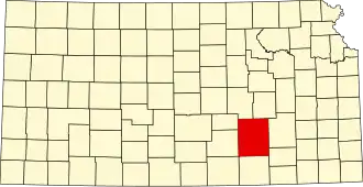 | |
| CDPs | ||
| Unincorporated communities | ||
| Ghost towns | ||
| Townships | ||