Walnut Grove, Washington County, Arkansas
Walnut Grove, Arkansas | |
|---|---|
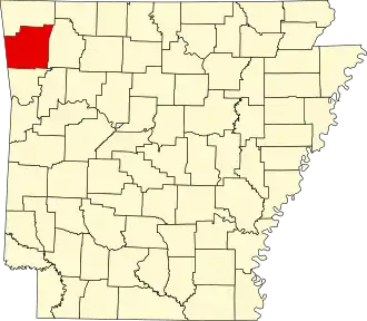
 Walnut Grove, Arkansas Walnut Grove's position in Arkansas.  Walnut Grove, Arkansas Walnut Grove, Arkansas (the United States) | |
| Coordinates: 36°00′13″N 94°16′02″W / 36.00361°N 94.26722°W | |
| Country | |
| State | |
| County | Washington |
| Township | Center |
| Elevation | 354 m (1,161 ft) |
| Time zone | UTC-6 (Central (CST)) |
| • Summer (DST) | UTC-5 (CDT) |
| Area code | 479 |
| GNIS feature ID | 73997 |
| U.S. Geological Survey Geographic Names Information System: Walnut Grove, Washington County, Arkansas | |
Walnut Grove is an unincorporated community in Center Township, Washington County, Arkansas, United States.[1] It is located on Arkansas Highway 170, south of Farmington.[2]
References
- ^ "Feature Detail Report for: , Arkansas." USGS. U.S. Geological Survey Geographic Names Information System: Walnut Grove, Washington County, Arkansas Retrieved September 23, 2010.
- ^ Arkansas Atlas and Gazetteer (Map) (Second ed.). DeLorme. § 22.