Vistula, Indiana
Vistula, Indiana | |
|---|---|
 Vistula  Vistula | |
| Coordinates: 41°44′57″N 85°43′24″W / 41.74917°N 85.72333°W | |
| Country | United States |
| State | Indiana |
| County | Elkhart |
| Township | York |
| Elevation | 794 ft (242 m) |
| ZIP code | 46507 |
| FIPS code | 18-79226[2] |
| GNIS feature ID | 2830368[1] |
Vistula is an unincorporated community in York Township, Elkhart County, Indiana.
History
Vistula was laid out in 1865.[3] It was likely named after the Vistula River.[4]
Demographics
| Census | Pop. | Note | %± |
|---|---|---|---|
| 2023 (est.) | 45 | [5] |
The United States Census Bureau defined Vistula as a census designated place in the 2022 American Community Survey.[6]
References
- ^ a b U.S. Geological Survey Geographic Names Information System: Vistula, Indiana
- ^ "U.S. Census website". United States Census Bureau. Retrieved January 31, 2008.
- ^ History of Elkhart County, Indiana. Chas. C. Chapman Co. 1881. pp. 1173.
- ^ Baker, Ronald L. (October 1995). From Needmore to Prosperity: Hoosier Place Names in Folklore and History. Indiana University Press. p. 335. ISBN 978-0-253-32866-3.
...probably for the river in Northern Europe...
- ^ "B03002 Hispanic or Latino, and Not Hispanic or Latino by Race – Vistula CDP – 2023 American Community Survey 5-Year Estimates". U.S. Census Bureau. July 1, 2023. Retrieved August 1, 2025.
- ^ "2022 Geography Changes". United States Census Bureau.
External links
Municipalities and communities of Elkhart County, Indiana, United States | ||
|---|---|---|
| Cities | 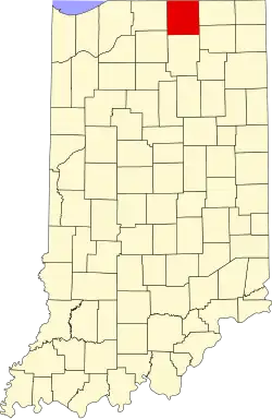 | |
| Towns | ||
| Townships | ||
| CDPs | ||
| Other communities | ||
| Footnotes | ‡This populated place also has portions in an adjacent county or counties | |