Traders Point Eagle Creek Rural Historic District
Traders Point Eagle Creek Rural Historic District | |
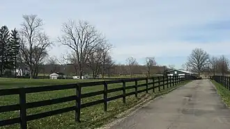 Farm in the Traders Point Rural Historic District, March 2011 | |
   | |
| Location | Roughly between Interstate 865, Interstate 465, and Lafayette Rd., Pike Township, Marion County, Indiana and Eagle Township, Boone County, Indiana |
|---|---|
| Coordinates | 39°55′32″N 86°17′47″W / 39.92556°N 86.29639°W |
| Area | 1,489 acres (603 ha) |
| Built by | Osler, Richard |
| Architectural style | Federal, Greek Revival |
| MPS | Eagle Township and Pike Township, Indiana MPS |
| NRHP reference No. | 09000433[1] |
| Added to NRHP | June 17, 2009 |
Traders Point Eagle Creek Rural Historic District is a national historic district located at Pike Township, Marion County, Indiana, and Eagle Township, Boone County, Indiana. The district encompasses 109 contributing buildings, 40 contributing sites, and 12 contributing structures in a rural area near Indianapolis. The district is characterized by the agricultural landscape, farmsteads and estates, recreational landscapes, transportation features including roads and bridges, and historic cemeteries.[2]
It was listed on the National Register of Historic Places in 2009.[1]
See also
- National Register of Historic Places listings in Boone County, Indiana
- National Register of Historic Places listings in Marion County, Indiana
References
- ^ a b "National Register Information System". National Register of Historic Places. National Park Service. July 9, 2010.
- ^ "Indiana State Historic Architectural and Archaeological Research Database (SHAARD)" (Searchable database). Department of Natural Resources, Division of Historic Preservation and Archaeology. Retrieved July 1, 2015. Note: This includes Camille B. Fife (May 2008). "National Register of Historic Places Inventory Nomination Form: Traders Point Eagle Creek Rural Historic District" (PDF). Retrieved July 1, 2015. and Accompanying photographs.