Točník
Točník | |
|---|---|
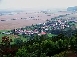 Točník from the Točník Castle | |
 Flag  Coat of arms | |
 Točník Location in the Czech Republic | |
| Coordinates: 49°53′8″N 13°52′58″E / 49.88556°N 13.88278°E | |
| Country | |
| Region | Central Bohemian |
| District | Beroun |
| First mentioned | 1390 |
| Area | |
• Total | 5.38 km2 (2.08 sq mi) |
| Elevation | 345 m (1,132 ft) |
| Population (2025-01-01)[1] | |
• Total | 269 |
| • Density | 50/km2 (130/sq mi) |
| Time zone | UTC+1 (CET) |
| • Summer (DST) | UTC+2 (CEST) |
| Postal code | 267 51 |
| Website | tocnik-obec |
Točník is a municipality and village in Beroun District in the Central Bohemian Region of the Czech Republic. It has about 300 inhabitants.
Demographics
| Year | Pop. | ±% |
|---|---|---|
| 1869 | 281 | — |
| 1880 | 280 | −0.4% |
| 1890 | 290 | +3.6% |
| 1900 | 274 | −5.5% |
| 1910 | 267 | −2.6% |
| 1921 | 250 | −6.4% |
| 1930 | 209 | −16.4% |
| 1950 | 186 | −11.0% |
| 1961 | 226 | +21.5% |
| 1970 | 259 | +14.6% |
| 1980 | 273 | +5.4% |
| 1991 | 259 | −5.1% |
| 2001 | 238 | −8.1% |
| 2011 | 249 | +4.6% |
| 2021 | 256 | +2.8% |
| Source: Censuses[2][3] | ||
Sights
The municipality is known for the ruins of the medieval Žebrák and Točník castles. Together they are protected as a national cultural monument.[4]
Gallery
-
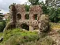 Žebrák Castle ruins
 -
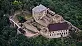 Točník Castle
References
- ^ "Population of Municipalities – 1 January 2025". Czech Statistical Office. 2025-05-16.
- ^ "Historický lexikon obcí České republiky 1869–2011" (in Czech). Czech Statistical Office. 2015-12-21.
- ^ "Population Census 2021: Population by sex". Public Database. Czech Statistical Office. 2021-03-27.
- ^ "Hrad Točník" (in Czech). National Heritage Institute. Retrieved 2024-01-29.
External links
Wikimedia Commons has media related to Točník.