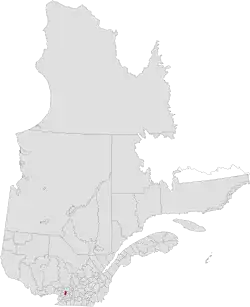
Thérèse-De Blainville Regional County Municipality
Thérèse-De Blainville | |
|---|---|
 Location in province of Quebec. | |
| Coordinates: 45°40′N 73°53′W / 45.667°N 73.883°W[1] | |
| Country | |
| Province | |
| Region | Laurentides |
| Effective | May 26, 1982 |
| County seat | Sainte-Thérèse |
| Government | |
| • Type | Prefecture |
| • Prefect | Eric Westram |
| Area | |
• Total | 211.90 km2 (81.82 sq mi) |
| • Land | 206.52 km2 (79.74 sq mi) |
| Population (2021)[4] | |
• Total | 163,632 |
| • Density | 792.3/km2 (2,052/sq mi) |
| • Change 2016–2021 | |
| Time zone | UTC−5 (EST) |
| • Summer (DST) | UTC−4 (EDT) |
| Area codes | 450 and 579 |
| Website | www |
Thérèse-De Blainville (French pronunciation: [teʁɛz də blɛ̃vil]) is a regional county municipality in the Laurentides region of Quebec, Canada. It is located immediately north of Laval on the north shore of the Rivière des Mille-Îles.
The population according to the 2021 Canadian Census was 163,632.[3]
Subdivisions
There are 7 subdivisions within the RCM, and they are all classified as "Villes" (City or Town):[2]
| Cities & Towns | Population (2021)[3] | Population (2016)[3] | Change (%) 2016-2021[3] | Land Area (km2)[3] | Land Area (mi2)[3] | Population density (km2)[3] | Population density (mi2)[3] |
|---|---|---|---|---|---|---|---|
| Blainville | 59,819 | 56,863 | +5.2% | 54.97 | 21.22 | 1,088 | 2,819 |
| Bois-des-Filion | 10,159 | 9,636 | +5.4% | 4.36 | 1.68 | 2,330 | 6,047 |
| Boisbriand | 28,308 | 26,884 | +5.3% | 27.67 | 10.68 | 1,023 | 2,651 |
| Lorraine | 9,502 | 9,352 | +1.6% | 5.90 | 2.28 | 1,611 | 4,168 |
| Rosemère | 14,090 | 13,958 | +0.9% | 10.68 | 4.12 | 1,319 | 3,420 |
| Sainte-Anne-des-Plaines | 15,221 | 14,421 | +5.5% | 93.44 | 36.08 | 163 | 422 |
| Sainte-Thérèse | 26,533 | 25,989 | +2.1% | 9.48 | 3.66 | 2,799 | 7,249 |
| Total | 163,632 | 157,103 | +4.2% | 206.52 | 79.74 | 792 | 2,052 |
| Canada Census Mother Tongue - Thérèse-de-Blainville, Quebec[4] | ||||||||||||||||||
|---|---|---|---|---|---|---|---|---|---|---|---|---|---|---|---|---|---|---|
| Census | Total | French
|
English
|
French & English
|
Other
| |||||||||||||
| Year | Responses | Count | Trend | Pop % | Count | Trend | Pop % | Count | Trend | Pop % | Count | Trend | Pop % | |||||
2021
|
161,370
|
130,925 | 81.13% | 7,785 | 4.8% | 2,750 | 1.7% | 17,135 | 10.61% | |||||||||
2016
|
155,865
|
133,825 | 85.85% | 6,685 | 4.28% | 1,575 | 1.01% | 12,385 | 7.95% | |||||||||
2011
|
154,144
|
133,980 | 86.91% | 6,250 | 4.05% | 1,355 | 0.87% | 10,115 | 6.56% | |||||||||
2006
|
143,370
|
126,740 | 89.09% | 5,920 | 4.12% | 1,060 | 0.73% | 8,535 | 5.95% | |||||||||
2001
|
130,514
|
115,850 | 88.76% | 5,640 | 4.32% | 810 | 0.62% | 6,815 | 5.22% | |||||||||
1996
|
119,240
|
105,870 | n/a | 88.78% | 5,605 | n/a | 4.7% | 970 | n/a | 0.81% | 5,190 | n/a | 4.35% | |||||
Transportation
Access Routes
Highways and numbered routes that run through the municipality, including external routes that start or finish at the county border:[5]
|
|
|
See also
References
- ^ "Banque de noms de lieux du Québec: Reference number 141035". toponymie.gouv.qc.ca (in French). Commission de toponymie du Québec.
- ^ a b c "Répertoire des municipalités: Geographic code 730". www.mamh.gouv.qc.ca (in French). Ministère des Affaires municipales et de l'Habitation.
- ^ a b c d e f g h i "Census Profile, 2021 Census: Thérèse-De Blainville, Municipalité régionale de comté [Census division], Quebec". Statistics Canada. Retrieved July 27, 2025.
- ^ a b Statistics Canada: 1996, 2001, 2006, 2011, 2016, 2021 census
- ^ Official Transport Quebec Road Map