Tatrovice
Tatrovice | |
|---|---|
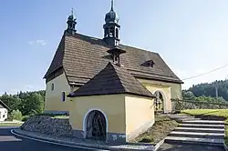 Church of Saint Erhard | |
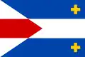 Flag 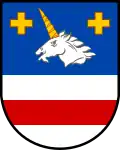 Coat of arms | |
 Tatrovice Location in the Czech Republic | |
| Coordinates: 50°16′37″N 12°41′50″E / 50.27694°N 12.69722°E | |
| Country | |
| Region | Karlovy Vary |
| District | Sokolov |
| First mentioned | 1356 |
| Area | |
• Total | 10.13 km2 (3.91 sq mi) |
| Elevation | 564 m (1,850 ft) |
| Population (2025-01-01)[1] | |
• Total | 162 |
| • Density | 16/km2 (41/sq mi) |
| Time zone | UTC+1 (CET) |
| • Summer (DST) | UTC+2 (CEST) |
| Postal code | 357 35 |
| Website | www |
Tatrovice (German: Dotterwies) is a municipality and village in Sokolov District in the Karlovy Vary Region of the Czech Republic. It has about 200 inhabitants.
Demographics
| Year | Pop. | ±% |
|---|---|---|
| 1869 | 588 | — |
| 1880 | 581 | −1.2% |
| 1890 | 681 | +17.2% |
| 1900 | 694 | +1.9% |
| 1910 | 718 | +3.5% |
| 1921 | 697 | −2.9% |
| 1930 | 745 | +6.9% |
| 1950 | 153 | −79.5% |
| 1961 | 173 | +13.1% |
| 1970 | 140 | −19.1% |
| 1980 | 131 | −6.4% |
| 1991 | 112 | −14.5% |
| 2001 | 134 | +19.6% |
| 2011 | 168 | +25.4% |
| 2021 | 160 | −4.8% |
| Source: Censuses[2][3] | ||
References
- ^ "Population of Municipalities – 1 January 2025". Czech Statistical Office. 2025-05-16.
- ^ "Historický lexikon obcí České republiky 1869–2011" (in Czech). Czech Statistical Office. 2015-12-21.
- ^ "Population Census 2021: Population by sex". Public Database. Czech Statistical Office. 2021-03-27.
External links
Wikimedia Commons has media related to Tatrovice.