Taboye
Taboye | |
|---|---|
Commune and village | |
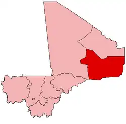
 Taboye Location in Mali | |
| Coordinates: 16°42′53″N 0°15′31″W / 16.71472°N 0.25861°W | |
| Country | |
| Region | Gao Region |
| Cercle | Bourem Cercle |
| Area | |
• Total | 1,452 km2 (561 sq mi) |
| Population (2009 Census)[2] | |
• Total | 20,503 |
| • Density | 14/km2 (37/sq mi) |
| Time zone | UTC+0 (GMT) |
Taboye is a rural commune and village in the Cercle of Bourem in the Gao Region of south-eastern Mali. The commune is crossed by the River Niger and includes the villages of Bia, Dagha, Ha, Moudakane, Ouani, Tondibi and Taboye. In the 2009 census the commune had a population of 20,503.
References
- ^ Schéma Directeur de Lutte Contre L’ensablement dans le Nord Du Mali (6ème Et 7ème Régions): Monographie de la Commune de Taboye (PDF) (in French), Ministère de l’Environnement et de L’assainissement, République du Mali, 2004, archived from the original (PDF) on 2011-10-06.
- ^ Resultats Provisoires RGPH 2009 (Région de Gao) (PDF) (in French), République de Mali: Institut National de la Statistique, archived from the original (PDF) on 2011-07-22, retrieved 2011-01-25
{{citation}}: CS1 maint: publisher location (link).
External links
- Plan de Sécurité Alimentaire Commune de Taboye 2005-2009 (PDF) (in French), Commissariat à la Sécurité Alimentaire, République du Mali, USAID-Mali, 2005, archived from the original (PDF) on 2012-05-13.