Sutherland, Tennessee
Sutherland, Tennessee | |
|---|---|
 Sutherland  Sutherland | |
| Coordinates: 36°36′15″N 81°48′36″W / 36.60417°N 81.81000°W | |
| Country | United States |
| State | Tennessee |
| County | Johnson |
| Elevation | 2,090 ft (640 m) |
| Time zone | UTC-5 (Eastern (EST)) |
| • Summer (DST) | UTC-4 (EDT) |
| Area code | 423 |
| GNIS feature ID | 1327166[1] |
Sutherland is an unincorporated community in Johnson County, Tennessee, United States. Sutherland is located .6 miles (0.97 km) south of the border with Virginia on Tennessee State Route 133.[2]
References
- ^ "Sutherland". Geographic Names Information System. United States Geological Survey, United States Department of the Interior.
- ^ Johnson County, Tennessee General Highway Map (PDF) (Map). Tennessee Department of Transportation. 2005. Retrieved December 15, 2012.
Municipalities and communities of Johnson County, Tennessee, United States | ||
|---|---|---|
| Town | 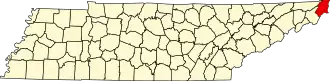 | |
| CDP | ||
| Other communities | ||
| Footnotes | ‡This populated place also has portions in an adjacent county or counties | |