Sumner, Oklahoma
Sumner, Oklahoma | |
|---|---|
 Sumner, Oklahoma Location within the state of Oklahoma  Sumner, Oklahoma Sumner, Oklahoma (the United States) | |
| Coordinates: 36°19′8″N 97°7′17″W / 36.31889°N 97.12139°W | |
| Country | United States |
| State | Oklahoma |
| County | Noble |
| Area | |
• Total | 0.15 sq mi (0.38 km2) |
| • Land | 0.15 sq mi (0.38 km2) |
| • Water | 0.00 sq mi (0.00 km2) |
| Elevation | 938 ft (286 m) |
| Population (2020) | |
• Total | 35 |
| • Density | 239.73/sq mi (92.87/km2) |
| Time zone | UTC-6 (Central (CST)) |
| • Summer (DST) | UTC-5 (CDT) |
| FIPS code | 40-71500 |
| GNIS feature ID | 2812860[2] |
Sumner is an unincorporated community and census-designated place[2] located in Noble County, Oklahoma, United States, ten miles east of Perry and two miles north of U.S. Route 64. Established prior to statehood along the St. Louis-San Francisco Railway, the post office opened on May 23, 1894. The town was named for Henry T. Sumner, a businessman from Perry. Per the 1905 Oklahoma Territorial Census, Sumner had sixty-four residents. The post office closed July 27, 1957.
The town currently has a population of approximately fifty. At its peak the town had a bank, post office, two churches, a school, a grain elevator, and a train stop. Currently, the only significant buildings still in use are the Baptist church, the Christian church and the school.
Demographics
| Census | Pop. | Note | %± |
|---|---|---|---|
| 2020 | 35 | — | |
| U.S. Decennial Census[3] | |||
References
- ^ "ArcGIS REST Services Directory". United States Census Bureau. Retrieved September 20, 2022.
- ^ a b c U.S. Geological Survey Geographic Names Information System: Sumner, Oklahoma
- ^ "Census of Population and Housing". Census.gov. Retrieved June 4, 2016.
- Shirk, George H. Oklahoma Place Names. Norman: University of Oklahoma Press, 1987. ISBN 0-8061-2028-2.
Municipalities and communities of Noble County, Oklahoma, United States | ||
|---|---|---|
| City | 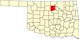 | |
| Towns | ||
| CDPs | ||
| Other communities | ||