Subprefecture of Parelheiros
Subprefecture of Parelheiros | |
|---|---|
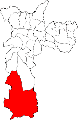 Location of the Subprefecture of Parelheiros in São Paulo | |
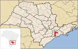 Location of municipality of São Paulo within the State of São Paulo | |
| Country | |
| Region | Southeast |
| State | |
| Municipality | |
| Administrative Zone | South |
| Districts | Parelheiros, Marsilac |
| Government | |
| • Type | Subprefecture |
| • Subprefect | Noel Miranda Castro |
| Area | |
• Total | 360.6 km2 (139.2 sq mi) |
| Population (2005) | |
• Total | 148,239 |
| Website | Subprefecture of Parelheiros (Portuguese) |
The Subprefecture of Parelheiros is one of 32 subprefectures of the city of São Paulo, Brazil. It comprises two districts: Parelheiros and Marsilac.[1]
It's the southernmost, least populated and poorest borough of São Paulo. Most of its area is rural, covered by parts of the Atlantic Rainforest.
Public Equipment
See also
- Line 9 of Train (CPTM)
- Roman Catholic Diocese of Santo Amaro
- Parelheiros-Itanhaém Highway 57
- Guarapiranga Reservoir
- Colônia crater
References
External links
- Subprefecture of Parelheiros
- Roman Catholic Diocese of Santo Amaro
- Official page of the São Paulo Metropolitan Trains Company