Stones Corner, Oklahoma
Stones Corner, Oklahoma | |
|---|---|
 Stones Corner, Oklahoma | |
| Coordinates: 35°52′16″N 95°36′24″W / 35.87111°N 95.60667°W | |
| Country | United States |
| State | Oklahoma |
| County | Wagoner |
| Elevation | 561 ft (171 m) |
| Time zone | UTC-6 (Central (CST)) |
| • Summer (DST) | UTC-5 (CDT) |
| Area codes | 539 & 918 |
| GNIS feature ID | 1100856[1] |
Stones Corner is an unincorporated community in Wagoner County, Oklahoma, United States. It is located at the junction of Oklahoma State highways 51B and 104, approximately 4 1/2 miles west of Porter, and seven miles south of Coweta. Primarily a farming community, it once was home to a farm equipment dealer and repair shop, and Stones Corner filling station and grocery, until the latter burned down in the late 1980s.
References
Municipalities and communities of Wagoner County, Oklahoma, United States | ||
|---|---|---|
| Cities | 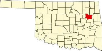 | |
| Towns | ||
| CDPs | ||
| Other communities | ||
| Indian reservations | ||
| Footnotes | ‡This populated place also has portions in an adjacent county or counties | |