Stolpe auf Usedom
Stolpe auf Usedom | |
|---|---|
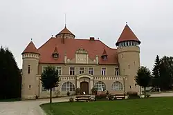 Stolpe Castle | |
Location of Stolpe auf Usedom within Vorpommern-Greifswald district 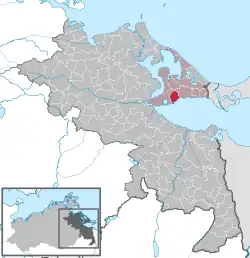 | |
 Stolpe auf Usedom  Stolpe auf Usedom | |
| Coordinates: 53°52′N 14°00′E / 53.867°N 14.000°E | |
| Country | Germany |
| State | Mecklenburg-Vorpommern |
| District | Vorpommern-Greifswald |
| Municipal assoc. | Usedom-Süd |
| Government | |
| • Mayor | Eckhardt Schulz |
| Area | |
• Total | 14.86 km2 (5.74 sq mi) |
| Elevation | 0 m (0 ft) |
| Population (2023-12-31)[1] | |
• Total | 338 |
| • Density | 23/km2 (59/sq mi) |
| Time zone | UTC+01:00 (CET) |
| • Summer (DST) | UTC+02:00 (CEST) |
| Postal codes | 17406 |
| Dialling codes | 038372 |
| Vehicle registration | VG |
Stolpe auf Usedom is a municipality in the Vorpommern-Greifswald district, in Mecklenburg-Vorpommern, Germany.
References
External links
![]() Media related to Stolpe auf Usedom at Wikimedia Commons
Media related to Stolpe auf Usedom at Wikimedia Commons