Stanetinci, Cerkvenjak
Stanetinci | |
|---|---|
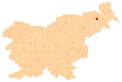
 Stanetinci Location in Slovenia | |
| Coordinates: 46°33′24.8″N 15°56′37.5″E / 46.556889°N 15.943750°E | |
| Country | |
| Traditional region | Styria |
| Statistical region | Drava |
| Municipality | Cerkvenjak |
| Area | |
• Total | 1.89 km2 (0.73 sq mi) |
| Elevation | 323.5 m (1,061.4 ft) |
| Population (2020) | |
• Total | 145 |
| • Density | 77/km2 (200/sq mi) |
| [1] | |
Stanetinci (pronounced [ˈstaːnɛtintsi]) is a settlement in the Municipality of Cerkvenjak in northeastern Slovenia. It lies in the Slovene Hills (Slovene: Slovenske gorice) south of Cerkvenjak. The area is part of the traditional region of Styria and is now included in the Drava Statistical Region.[2]
A small Neo-Gothic chapel-shrine in the settlement was built in the last quarter of the 19th century.[3]
References
External links
| Settlements | Administrative seat: Cerkvenjak
|  |
|---|---|---|
| Landmarks | ||