Srednja Vas–Goriče
Srednja Vas–Goriče
Srednja Vas (until 1953) | |
|---|---|
 | |
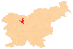
 Srednja Vas–Goriče Location in Slovenia | |
| Coordinates: 46°19′17.18″N 14°21′0.64″E / 46.3214389°N 14.3501778°E | |
| Country | |
| Traditional region | Upper Carniola |
| Statistical region | Upper Carniola |
| Municipality | Kranj |
| Area | |
• Total | 0.82 km2 (0.32 sq mi) |
| Elevation | 490.9 m (1,610.6 ft) |
| Population (2012) | |
• Total | 80 |
| • Density | 98/km2 (250/sq mi) |
| [1] | |
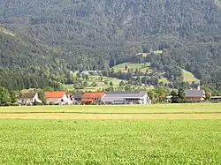
Srednja Vas–Goriče (pronounced [ˈsɾeːdnja ˈʋaːs ɡɔˈɾiːtʃɛ]; Slovene: Srednja vas - Goriče,[1] German: Srednawas[2]) is a settlement near Golnik in the Municipality of Kranj in the Upper Carniola region of Slovenia.[3]
Name
The name of the settlement was changed from Srednja vas to Srednja vas - Goriče in 1953.[4] In the past the German name was Srednawas.[2]
Cultural heritage
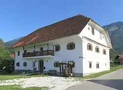
The house at the Crk farm (Slovene: Pr' Crku) at no. 17 in Srednja Vas–Goriče is registered as cultural heritage. It is a two-story manor house with a half-hip roof, window frames carved from tuff, cast-iron window gratings, and a balcony, dating from the mid-19th century and standing along the road from Goriče to Zalog. In addition to the house, the farm consists of a barn, a pigsty, a granary, a woodshed, other outbuildings, and an orchard.[5]
References
- ^ a b "Srednja vas - Goriče". Place Names. Statistical Office of the Republic of Slovenia. Retrieved 8 August 2012.
- ^ a b Leksikon občin kraljestev in dežel zastopanih v državnem zboru, vol. 6: Kranjsko. 1906. Vienna: C. Kr. Dvorna in Državna Tiskarna, p. 54.
- ^ Kranj municipal site
- ^ Spremembe naselij 1948–95. 1996. Database. Ljubljana: Geografski inštitut ZRC SAZU, DZS.
- ^ "Srednja vas-Goriče - Domačija Srednja vas 17". Register kulturne dediščine. Republika Slovenija, Ministrstvo za kulturo. Retrieved August 19, 2024.
External links
 Media related to Srednja Vas–Goriče at Wikimedia Commons
- Srednja Vas–Goriče on Geopedia