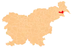
Spodnji Kamenščak
Spodnji Kamenščak | |
|---|---|
 Spodnji Kamenščak Location in Slovenia | |
| Coordinates: 46°30′47.94″N 16°10′43.94″E / 46.5133167°N 16.1788722°E | |
| Country | |
| Traditional region | Styria |
| Statistical region | Mura |
| Municipality | Ljutomer |
| Area | |
• Total | 2.37 km2 (0.92 sq mi) |
| Elevation | 222.2 m (729.0 ft) |
| Population (2002) | |
• Total | 418 |
| [1] | |
Spodnji Kamenščak (pronounced [ˈspoːdnji ˈkaːmɛnʃtʃak], German: Untersteinberg[2]) is a settlement in the hills southwest of Ljutomer in northeastern Slovenia. The area belongs to the traditional region of Styria and is now included in the Mura Statistical Region.[3]
References
- ^ Statistical Office of the Republic of Slovenia
- ^ Leksikon občin kraljestev in dežel zastopanih v državnem zboru, vol. 4: Štajersko. Vienna: C. Kr. Dvorna in Državna Tiskarna. 1904. p. 183.
- ^ Ljutomer municipal site
External links
| Settlements | Administrative seat: Ljutomer
|  |
|---|---|---|
| Landmarks | ||
| Notable people |
| |