Southeastern Connecticut Planning Region, Connecticut
Southeastern Connecticut Planning Region | |
|---|---|
| Southeastern Connecticut Council of Governments (SCCOG) | |
  _passes_by_the_historic_ship_USS_Nautilus.jpg)   | |
|
Logo | |
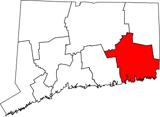 Location within the U.S. state of Connecticut | |
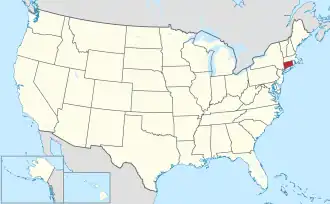 Connecticut's location within the U.S. | |
| Coordinates: 41°29′N 72°05′W / 41.49°N 72.09°W | |
| Country | |
| State | |
| Founded | 1992[1] |
| Largest city | Norwich |
| Other cities | New London, Willimantic, Groton |
| Government | |
| • Executive Director | Amanda E. Kennedy |
| Area | |
• Total | 598.1 sq mi (1,549 km2) |
| Population (2020) | |
• Total | 280,430 |
| Time zone | UTC−5 (Eastern) |
| • Summer (DST) | UTC−4 (EDT) |
| Congressional district | 2nd |
| Website | seccog |
The Southeastern Connecticut Planning Region is a planning region and county-equivalent in Connecticut. It is served by the coterminous Southeastern Connecticut Council of Governments (SCCOG). In 2022, planning regions were approved to replace Connecticut's counties as county-equivalents for statistical purposes, with full implementation occurring by 2024.[2][3]
Demographics
| Census | Pop. | Note | %± |
|---|---|---|---|
| 2010 | 290,198 | — | |
| 2020 | 280,430 | −3.4% | |
| 2022 (est.) | 280,403 | [4] | 0.0% |
| U.S. Decennial Census[3] | |||
As of the 2020 United States census, there were 280,430 people living in the Southeastern Planning Region.[3]
Municipalities
The following municipalities are members of the Southeastern Connecticut Region:[5]
Cities
Towns
- Bozrah
- Colchester
- East Lyme
- Franklin
- Griswold
- Groton
- Jewett City
- Lebanon
- Ledyard
- Lisbon
- Montville
- North Stonington
- Preston
- Salem
- Sprague
- Stonington
- Waterford
- Windham
References
- ^ https://seccog.org/
- ^ "Governor Lamont Announces U.S. Census Bureau Approves Proposal for Connecticut's Planning Regions To Become County Equivalents". CT.gov. Archived from the original on June 6, 2022. Retrieved March 24, 2023.
- ^ a b c "Change to County-Equivalents in the State of Connecticut". Federal Register. June 6, 2022. Retrieved March 24, 2023.
- ^ "U.S. Census Bureau QuickFacts: Southeastern Connecticut Planning Region, Connecticut; United States". www.census.gov. Retrieved May 13, 2023.
- ^ "SCCOG Members". Southeastern Connecticut Council of Governments. Retrieved March 24, 2023.
External links
Wikimedia Commons has media related to Southeastern Connecticut Planning Region, Connecticut.