Shibboleth, Kansas
Shibboleth, Kansas | |
|---|---|
 Shibboleth  Shibboleth | |
| Coordinates: 39°38′02″N 100°31′17″W / 39.63389°N 100.52139°W[1] | |
| Country | United States |
| State | Kansas |
| County | Decatur |
| Elevation | 2,677 ft (816 m) |
| Population | |
• Total | 0 |
| Time zone | UTC-6 (CST) |
| • Summer (DST) | UTC-5 (CDT) |
| Area code | 785 |
| GNIS ID | 481999 [1] |
Shibboleth is a former post village in Decatur County, Kansas, United States.[1][2] Shibboleth Cemetery is located in the eastern part of the present-day Prairie Dog Township.
History
Shibboleth was issued a post office in 1875. The post office was discontinued at the end of 1904.[3]
References
- ^ a b c d "Shibboleth, Kansas", Geographic Names Information System, United States Geological Survey, United States Department of the Interior
- ^ Gannett, Henry (1898). A Gazetteer of Kansas. U.S. Government Printing Office.
- ^ "Kansas Post Offices, 1828-1961 - Kansas Historical Society". www.kshs.org. Retrieved January 21, 2024.
Further reading
Municipalities and communities of Decatur County, Kansas, United States | ||
|---|---|---|
| Cities | 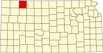 | |
| Unincorporated communities | ||
| Ghost towns | ||
| Townships | ||
| Footnotes | ‡This community also has portions in an adjacent county or counties. | |