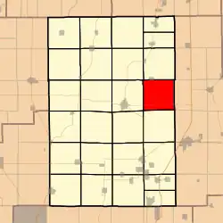
Shaws Point Township, Macoupin County, Illinois
Shaws Point Township | |
|---|---|
 | |
.svg.png) Location of Illinois in the United States | |
| Coordinates: 39°18′N 89°46′W / 39.300°N 89.767°W | |
| Country | United States |
| State | Illinois |
| County | Macoupin |
| Settled | November 1, 1870 |
| Area | |
• Total | 34.16 sq mi (88.5 km2) |
| • Land | 34.07 sq mi (88.2 km2) |
| • Water | 0.08 sq mi (0.2 km2) |
| Elevation | 633 ft (193 m) |
| Population (2010) | |
• Estimate (2016)[1] | 512 |
| • Density | 15.6/sq mi (6.0/km2) |
| Time zone | UTC-6 (CST) |
| • Summer (DST) | UTC-5 (CDT) |
| FIPS code | 17-117-69121 |
Shaws Point Township (T10N R6W) is located in Macoupin County, Illinois, United States. As of the 2010 census, its population was 532 and it contained 233 housing units.[2]
Geography
According to the 2010 census, the township has a total area of 34.16 square miles (88.5 km2), of which 34.07 square miles (88.2 km2) (or 99.74%) is land and 0.08 square miles (0.21 km2) (or 0.23%) is water.[2]
Demographics
| Census | Pop. | Note | %± |
|---|---|---|---|
| 2016 (est.) | 512 | [1] | |
| U.S. Decennial Census[3] | |||
Adjacent townships
- Nilwood Township (north)
- Zanesville Township, Montgomery County (east)
- North Litchfield Township, Montgomery County (southeast)
- Honey Point Township (south)
- Brushy Mound Township (southwest)
- Carlinville Township (west)
- South Otter Township (northwest)
References
- ^ a b "Population and Housing Unit Estimates". Retrieved June 9, 2017.
- ^ a b "Population, Housing Units, Area, and Density: 2010 - County -- County Subdivision and Place -- 2010 Census Summary File 1". United States Census. Archived from the original on February 12, 2020. Retrieved May 28, 2013.
- ^ "Census of Population and Housing". Census.gov. Retrieved June 4, 2016.
External links
Municipalities and communities of Macoupin County, Illinois, United States | ||
|---|---|---|
| Cities | 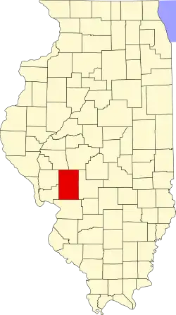 | |
| Town | ||
| Villages | ||
| Townships | ||
| Unincorporated communities | ||
| Footnotes | ‡This city also has portions in adjacent county or counties | |