Seo-myeon, Gyeongju
Seo-myeon | |
|---|---|
myeon | |
| Korean transcription(s) | |
| • Hangul | 서면 |
| • Hanja | 西面 |
| • Revised Romanization | Seo-myeon |
| • McCune–Reischauer | Sŏ-myŏn |
 | |
 Seo-myeon | |
| Coordinates: 35°53′08″N 129°03′52″E / 35.885573°N 129.064465°E | |
| Country | South Korea |
| Region | Gyeongju |
| Administrative divisions | 13 administrative ri (8 legal ri), 61 ban |
| Government | |
| • Type | Gyeongju City |
| Area | |
• Total | 52.12 km2 (20.12 sq mi) |
| Population (2006)[1] | |
• Total | 4,166 |
| • Density | 80/km2 (200/sq mi) |
| Dialect | Gyeongsang dialect |
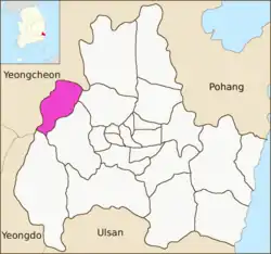
Seo-myeon is a myeon or a township in the subdivision of the Gyeongju City, North Gyeongsang province, South Korea. It is bordered by its neighborhoods including Hyeongok-myeon and Geoncheon-eup on the east, Sannae-myeon on the south and Yeongcheon City on the west and north. Its 52.12 square kilometers are home to about 4,166 people.[1] This population is served by one elementary school and one joint middle school.[2]
Administrative divisions
- Dogye-ri (도계리)
- Do-ri (도리)
- Sara-ri (사라리)
- Seoo-ri (서오리)
- Simgok-ri (심곡리)
- Undae-ri (운대리)
- Ihwa-ri (이화리)
- Cheonchon-ri (천촌리)
See also
References
- ^ a b "서면 Seo-myeon 西面" (in Korean). Doosan Encyclopedia. Archived from the original on 2013-01-02. Retrieved 2009-08-17.
- ^ 교육기관 [Educational institution] (in Korean). Gyeongju City. Retrieved 2009-08-17.
External links
- (in Korean) The official site of the Seo-myeon office
4 eup, 8 myeon, 11 dong | ||
| Eup (town) | 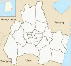 | |
| Myeon (township) | ||
| Dong (neighborhood) | ||
| See also | ||
Website: www.gyeongju.go.kr | ||