Sensée
| Sensée | |
|---|---|
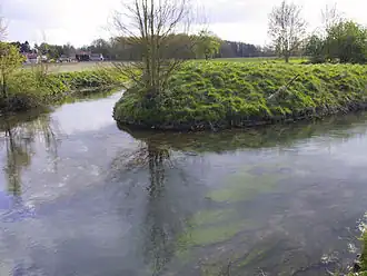 The Sensée near Remy | |
  | |
| Location | |
| Country | France |
| Region | Hauts-de-France |
| Physical characteristics | |
| Source | |
| • location | Picardie |
| • elevation | 111 m (364 ft) |
| Mouth | |
• location | Scheldt |
• coordinates | 50°16′46″N 3°18′38″E / 50.27944°N 3.31056°E |
| Length | 47 km (29 mi) |
| Basin size | 725 km2 (280 sq mi) |
| Basin features | |
| Progression | Scheldt→ North Sea |
The Sensée (French pronunciation: [sɑ̃se]; Picard: Sinsée) is a river in northern France that crosses the département of Pas-de-Calais. The source is found at Croisilles and passes through Lécluse. It crosses the Canal du Nord at Arleux, and joins the canalized Escaut at Bouchain. The average descent is 2.42%. It is 47 km (29 mi) long: 27 km (17 mi) upstream of the Canal du Nord,[1] and 20 km (12 mi) downstream of the Canal du Nord.[2]
The Sensée has many tributaries: the Cojeul, the Trinquise, the Hirondelle, the Agache and the Naville Tortue.
A 10th-century document refers to the river by the name of Sensada. The origins of the name are unknown.
See also
References
External links
(All French language)
- Water measuring station on the Sensée
- débits synthétiques sur la Banque HYDRO
- données débits moyens journaliers Année 2004 changer l'année dans la barre d'addresse
- comparaison 2005 / chronologie antérieure disponible changer l'année dans la barre d'addresse
- Dictionary of rivers and canals of France in Projet Babel
- General Information from the flood zones atlas