Selloi, Ioannina
Selloi
Σελλοί | |
|---|---|
 Selloi Location within the regional unit 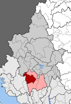 | |
| Coordinates: 39°31′N 20°41′E / 39.517°N 20.683°E | |
| Country | Greece |
| Administrative region | Epirus |
| Regional unit | Ioannina |
| Municipality | Dodoni |
| Area | |
| • Municipal unit | 166.432 km2 (64.260 sq mi) |
| Population (2021)[1] | |
| • Municipal unit | 1,088 |
| • Municipal unit density | 6.5/km2 (17/sq mi) |
| Time zone | UTC+2 (EET) |
| • Summer (DST) | UTC+3 (EEST) |
| Vehicle registration | ΙΝ |
Selloi (Greek: Σελλοί) is a former municipality in the Ioannina regional unit, Epirus, in northwestern Greece. Since the 2011 local government reform, it is part of the municipality of Dodoni, of which it is a municipal unit.[2] The municipal unit has an area of 166.432 km2.[3] Selloi is in the southwest of the Ioannina regional unit. The municipal unit is subdivided into fifteen communities.
The seat of the municipality was in Tyria, a village of the community of Baousioi next to the river Tyria. From there is passing the Via Egnatia Road (A/K of Selli). The name comes from the ancient Selloi who lived around Dodona.
Tourist sites include the cave of the bears, the Stournari Well and the Batzarion Cheese Factory.
References
- ^ "Αποτελέσματα Απογραφής Πληθυσμού - Κατοικιών 2021, Μόνιμος Πληθυσμός κατά οικισμό" [Results of the 2021 Population - Housing Census, Permanent population by settlement] (in Greek). Hellenic Statistical Authority. 29 March 2024.
- ^ "ΦΕΚ B 1292/2010, Kallikratis reform municipalities" (in Greek). Government Gazette.
- ^ "Population & housing census 2001 (incl. area and average elevation)" (PDF) (in Greek). National Statistical Service of Greece.