Sandia Park, New Mexico
Sandia Park, New Mexico | |
|---|---|
Census-designated place | |
 Sandia Park | |
| Coordinates: 35°10′02″N 106°22′18″W / 35.16722°N 106.37167°W | |
| Country | United States |
| State | New Mexico |
| County | Bernalillo |
| Area | |
• Total | 0.72 sq mi (1.88 km2) |
| • Land | 0.72 sq mi (1.88 km2) |
| • Water | 0.00 sq mi (0.00 km2) |
| Elevation | 7,071 ft (2,155 m) |
| Population | |
• Total | 265 |
| • Density | 365.52/sq mi (141.15/km2) |
| Time zone | UTC-7 (Mountain (MST)) |
| • Summer (DST) | UTC-6 (MDT) |
| ZIP code | 87047 |
| Area code | 505 |
| GNIS feature ID | 2584204[2] |
Sandia Park is a census-designated place in Bernalillo County, New Mexico, United States. Its population was 237 as of the 2010 census and 265 as of the 2020 census. Sandia Park has a post office with ZIP code 87047.[4][5]
Tinkertown Museum is an attraction in the area.
Demographics
| Census | Pop. | Note | %± |
|---|---|---|---|
| 2020 | 265 | — | |
| U.S. Decennial Census[6][3] | |||
Education
It is zoned to Albuquerque Public Schools.[7]
References
- ^ "ArcGIS REST Services Directory". United States Census Bureau. Retrieved October 12, 2022.
- ^ a b U.S. Geological Survey Geographic Names Information System: Sandia Park, New Mexico
- ^ a b "Census Population API". United States Census Bureau. Retrieved October 12, 2022.
- ^ United States Postal Service (2012). "USPS - Look Up a ZIP Code". Retrieved February 15, 2012.
- ^ "Postmaster Finder - Post Offices by ZIP Code". United States Postal Service. Retrieved August 17, 2013.
- ^ "Census of Population and Housing". Census.gov. Retrieved June 4, 2016.
- ^ "2020 CENSUS - SCHOOL DISTRICT REFERENCE MAP: Bernalillo County, NM" (PDF). U.S. Census Bureau. Retrieved July 20, 2021.
Municipalities and communities of Bernalillo County, New Mexico, United States | ||
|---|---|---|
| Cities | 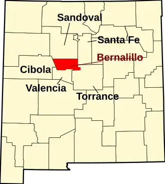 | |
| Town | ||
| Villages | ||
| CDPs | ||
| Other communities | ||
| Indian reservations | ||
| Footnotes | ‡This populated place also has portions in an adjacent county or counties | |