San Benito Abad
San Benito Abad | |
|---|---|
Municipality and town | |
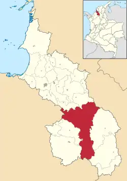 Location of the municipality and town of San Benito Abad in the Sucre Department of Colombia. | |
| Country | |
| Department | Sucre Department |
| Area | |
| • Land | 1,592 km2 (615 sq mi) |
| Elevation | 20 m (70 ft) |
| Population (2015) | |
• Municipality and town | 25,442 |
| • Urban | 5,314 |
| Demonym | Sanbenitino |
| Time zone | UTC-5 (Colombia Standard Time) |
San Benito Abad (Spanish pronunciation: [sam beˈnito aˈβað]) is a town and municipality located in the Sucre Department, northern Colombia.
Climate
| Climate data for San Benito Abad, elevation 20 m (66 ft), (1981–2010) | |||||||||||||
|---|---|---|---|---|---|---|---|---|---|---|---|---|---|
| Month | Jan | Feb | Mar | Apr | May | Jun | Jul | Aug | Sep | Oct | Nov | Dec | Year |
| Mean daily maximum °C (°F) | 32.5 (90.5) |
33.3 (91.9) |
33.8 (92.8) |
33.7 (92.7) |
32.6 (90.7) |
32.5 (90.5) |
32.2 (90.0) |
32.0 (89.6) |
31.9 (89.4) |
31.5 (88.7) |
31.6 (88.9) |
32.1 (89.8) |
32.4 (90.3) |
| Daily mean °C (°F) | 28.0 (82.4) |
28.4 (83.1) |
28.7 (83.7) |
28.6 (83.5) |
28.3 (82.9) |
28.2 (82.8) |
28.2 (82.8) |
28.1 (82.6) |
27.9 (82.2) |
27.8 (82.0) |
27.9 (82.2) |
27.9 (82.2) |
28.2 (82.8) |
| Mean daily minimum °C (°F) | 22.8 (73.0) |
23.0 (73.4) |
23.4 (74.1) |
23.7 (74.7) |
23.6 (74.5) |
23.4 (74.1) |
23.3 (73.9) |
23.0 (73.4) |
23.1 (73.6) |
23.3 (73.9) |
23.4 (74.1) |
23.2 (73.8) |
23.3 (73.9) |
| Average precipitation mm (inches) | 13.5 (0.53) |
14.7 (0.58) |
30.3 (1.19) |
114.7 (4.52) |
191.8 (7.55) |
227.2 (8.94) |
241.7 (9.52) |
252.3 (9.93) |
256.7 (10.11) |
216.0 (8.50) |
147.1 (5.79) |
50.7 (2.00) |
1,718.4 (67.65) |
| Average precipitation days | 1 | 2 | 3 | 7 | 13 | 14 | 15 | 15 | 15 | 15 | 11 | 4 | 113 |
| Average relative humidity (%) | 80 | 78 | 77 | 78 | 81 | 81 | 81 | 82 | 82 | 83 | 83 | 82 | 81 |
| Mean monthly sunshine hours | 254.2 | 217.4 | 192.2 | 171.0 | 161.2 | 189.0 | 217.0 | 210.8 | 171.0 | 179.8 | 180.0 | 223.2 | 2,366.8 |
| Mean daily sunshine hours | 8.2 | 7.7 | 6.2 | 5.7 | 5.2 | 6.3 | 7.0 | 6.8 | 5.7 | 5.8 | 6.0 | 7.2 | 6.5 |
| Source: Instituto de Hidrologia Meteorologia y Estudios Ambientales[1] | |||||||||||||
References
- ^ "Promedios Climatológicos 1981–2010" (in Spanish). Instituto de Hidrologia Meteorologia y Estudios Ambientales. Archived from the original on 15 August 2016. Retrieved 17 June 2024.
- (in Spanish) Gobernacion de Sucre - San Benito Abad
- (in Spanish) San Benito Abad official website
Municipalities in Sucre Department | ||
|---|---|---|
8°56′N 75°02′W / 8.933°N 75.033°W