Sahamamy
Sahamamy | |
|---|---|
 Sahamamy Location in Madagascar | |
| Coordinates: 17°31′S 48°18′E / 17.517°S 48.300°E | |
| Country | |
| Region | Alaotra-Mangoro |
| District | Amparafaravola |
| Population | |
• Total | 4,000 |
| Time zone | UTC3 (EAT) |
| Postal code | 504 |
Sahamamy is a rural municipality in Madagascar. It belongs to the district of Amparafaravola, which is a part of Alaotra-Mangoro Region. The population of the commune is not known, but in 2013 elections there had been 3942 authorized voters.[2]
Geography
This municipality is situated at 15 km North of Amparafaravola. 4 fokontany (villages) belong to this municipality.
Infrastructures
The National Road 3a crosses this municipality.
References
- ^ Estimated based on DEM data from Shuttle Radar Topography Mission
- ^ Malgasy elections
Capital: Ambatondrazaka | ||
| Ambatondrazaka (21) | 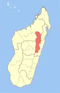 | |
| Amparafaravola (21) | ||
| Andilamena (8) | ||
| Anosibe An'ala (11) | ||
| Moramanga (22) | ||
5 districts; 82 communes | ||