Koriniti
%252C_Wanganui_(sic)_River_-_Google_Art_Project.jpg)
Koriniti is a settlement 47 kilometres (29 mi) upriver from Whanganui, New Zealand, home to the Ngāti Pāmoana hapū of the iwi Te Āti Haunui-a-Pāpārangi.[1]
The Māori settlement of Operiki was one of the larger on the Whanganui River, with a population of about 200. In 1848 the village was abandoned and a new one built in better agricultural land nearby at Otukopiri,[2] renamed Koriniti by the missionary Richard Taylor, a Māori transliteration of Corinth.[3]
Across the river from Koriniti, and reachable only by boat or cable car, is the Flying Fox lodge.[4]
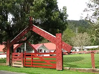
Marae
The local marae (Māori meeting place) is known as Koriniti Marae or Otukopiri Marae.[1] It has three wharenui (meeting houses):[5] Hikurangi Wharerata; the original whare Te Waiherehere, restored by Hõri Pukehika in 1921;[6] and Poutama, moved across the river from Karatia (Galatia) in 1967.[3]
Ōperika pā, the original home of Ngāti Pamoana, is nearby.[3]
In the 19th century Māori at Koriniti raised £400 to build a flour mill, which was completed in 1854, the same year as the Kawana flour mill near Matahiwi.[7]: 108
In October 2020, the Government committed $287,183 from the Provincial Growth Fund to upgrade the marae, creating 19 jobs.[8]
Notable people
- Rangi Hauiti Pōkiha (1895–1980), farmer, surveyor, and orator[9]
Climate
| Climate data for Ahu Ahu Valley (1991–2020) | |||||||||||||
|---|---|---|---|---|---|---|---|---|---|---|---|---|---|
| Month | Jan | Feb | Mar | Apr | May | Jun | Jul | Aug | Sep | Oct | Nov | Dec | Year |
| Mean daily maximum °C (°F) | 24.0 (75.2) |
24.3 (75.7) |
22.1 (71.8) |
19.0 (66.2) |
16.3 (61.3) |
13.3 (55.9) |
13.1 (55.6) |
14.0 (57.2) |
15.9 (60.6) |
17.8 (64.0) |
19.5 (67.1) |
22.3 (72.1) |
18.5 (65.2) |
| Daily mean °C (°F) | 18.0 (64.4) |
18.2 (64.8) |
16.1 (61.0) |
13.9 (57.0) |
11.7 (53.1) |
9.1 (48.4) |
8.5 (47.3) |
9.1 (48.4) |
10.9 (51.6) |
12.7 (54.9) |
14.2 (57.6) |
16.7 (62.1) |
13.3 (55.9) |
| Mean daily minimum °C (°F) | 12.1 (53.8) |
12.1 (53.8) |
10.1 (50.2) |
8.8 (47.8) |
7.0 (44.6) |
4.8 (40.6) |
3.9 (39.0) |
4.3 (39.7) |
5.8 (42.4) |
7.5 (45.5) |
8.8 (47.8) |
11.1 (52.0) |
8.0 (46.4) |
| Average rainfall mm (inches) | 81.5 (3.21) |
95.5 (3.76) |
108.6 (4.28) |
96.6 (3.80) |
107.7 (4.24) |
123.3 (4.85) |
120.9 (4.76) |
100.5 (3.96) |
96.7 (3.81) |
109.2 (4.30) |
101.2 (3.98) |
94.2 (3.71) |
1,235.9 (48.66) |
| Source: NIWA[10] | |||||||||||||
References
- ^ a b "Te Kāhui Māngai directory". tkm.govt.nz. Te Puni Kōkiri.
- ^ Walton, A. (1994). "Settlement Patterns in the Whanganui River Valley, 1839–1864" (PDF). New Zealand Journal of Archaeology. 16: 123–168.
- ^ a b c Beaglehole, Diana (20 March 2014). "Whanganui places: River Settlements". Te Ara: The Encyclopedia of New Zealand. Retrieved 17 November 2015.
- ^ "About Us". The Flying Fox. Archived from the original on 19 November 2015. Retrieved 19 November 2015.
- ^ "Koriniti Pā (Otukopiri)". Māori Maps. Archived from the original on 8 December 2015. Retrieved 19 November 2015.
- ^ Church, Ian (30 October 2012). "Pukehika, Hori". The Dictionary of New Zealand Biography. Te Ara – the Encyclopedia of New Zealand. Retrieved 21 November 2015.
- ^ Young, David (1998). Woven by Water (2004 ed.). Wellington: Huia Publishers. ISBN 0-908975-59-7.
- ^ "Marae Announcements" (Excel). growregions.govt.nz. Provincial Growth Fund. 9 October 2020.
- ^ Robinson, Penny. "Rangi Hauiti Pokiha". Dictionary of New Zealand Biography. Ministry for Culture and Heritage. Retrieved 23 April 2017.
- ^ "CliFlo – National Climate Database : Ahu Ahu Valley". NIWA. Retrieved 20 May 2024.
39°40′S 175°10′E / 39.667°S 175.167°E