Portal:Scottish islands
The Scottish Islands Portal
Welcome! — Fàilte! — Walcome!
-
-
-

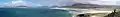
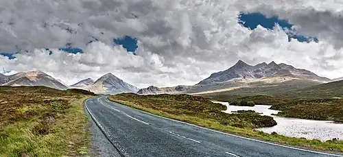
 View from Elgol on the Isle of Skye across to the Cuillin
 -
 Looking from the Isle of Mull towards Ardnamurchan peninsula as the Caledonian MacBrayne ferry MV Clansman sails past the Rubha nan Gall lighthouse
 -
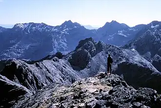
 The Cuillin, Isle of Skye
 -
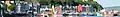
_P-SCO_Banner.jpg) Portree Waterfront, Isle of Skye
Portree Waterfront, Isle of Skye -
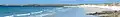
 Seilebost on Harris
 -
_P-SCO_Banner.jpg)
-
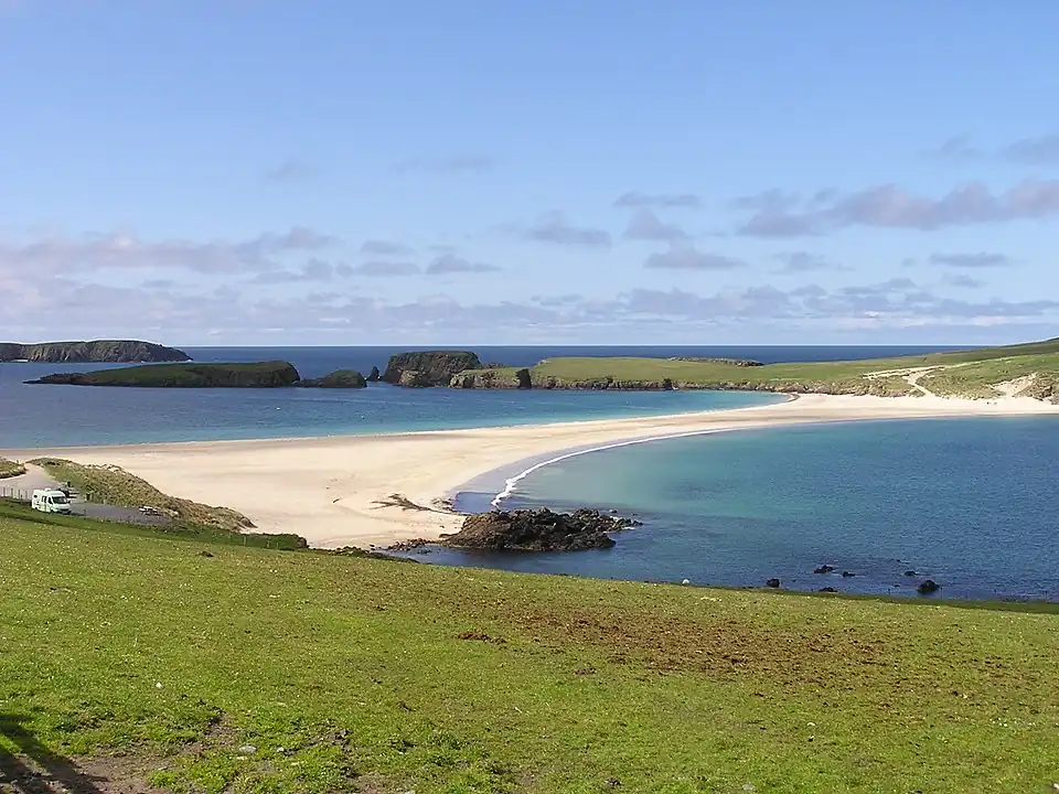
 Tombolo connecting St Ninian's Isle to Mainland, Shetland
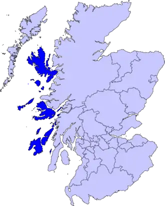
Scotland has around 900 offshore islands, most of which are to be found in four main groups: Shetland, Orkney, and the Hebrides, sub-divided into the Inner Hebrides and Outer Hebrides. There are also clusters of islands in the Firth of Clyde, Firth of Forth, and Solway Firth, and numerous small islands within the many bodies of fresh water in Scotland including Loch Lomond and Loch Maree. The largest island is Lewis and Harris, which extends to 2,179 km2 (841 sq mi), and there are a further 200 islands which are greater than 40 hectares (100 acres) in area. Of the remainder, several, such as Staffa and the Flannan Isles, are well-known, despite their small size. Some 101 Scottish islands are currently permanently inhabited, of which 96 are offshore islands. Between 2001 and 2011, Scottish island populations as a whole grew by 4% to 103,702 although by 2022 the total had fallen back to just under 103,000.
The geology and geomorphology of the islands is varied. Some, such as Skye and Mull, are mountainous, while others like Tiree and Sanday are relatively low-lying. Many have bedrock made from ancient Archaean Lewisian Gneiss which was formed 3 billion years ago; Shapinsay and other Orkney islands are formed from Old Red Sandstone, which is 400 million years old; and others such as Rùm from more recent Tertiary volcanoes. Many of the islands are swept by strong tides, and the Corryvreckan tide race between Scarba and Jura is one of the largest whirlpools in the world. Other strong tides are to be found in the Pentland Firth between mainland Scotland and Orkney, and another example is the "Grey Dog" between Scarba and Lunga. (More on Scottish islands...)
Selected picture
-
-
 The tied island of St Ninian's Isle is joined to the Shetland Mainland by the largest tombolo in the UK
Credit: ThoWi
-
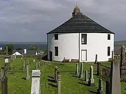 Kilarrow Parish Church, known as the Round Church, is a Georgian building in Bowmore on Islay
Credit: Ronsteenvoorden
-
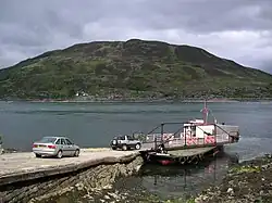 The ferry from Glenelg to Kylerhea on Skye has run for 400 years; the present boat, MV Glenachulish, is the only hand-operated turntable ferry still in operation
Credit: Wojsyl
-
-
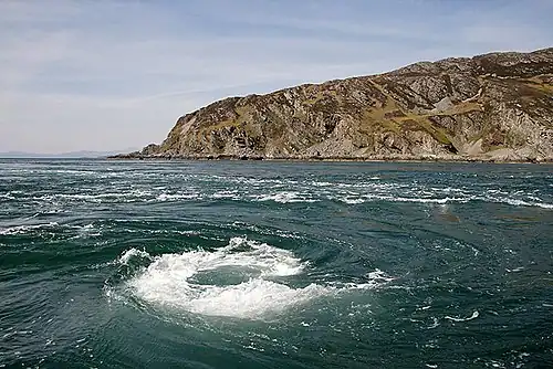 The Corryvreckan Whirlpool in the narrow Gulf of Corryvreckan between Jura and Scarba
Credit: Walter Baxter
-
.jpg)
-
-
.jpg)
-
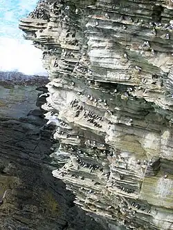
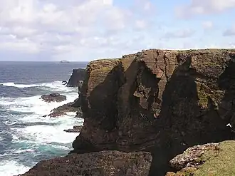 The cliffs of Eshaness, North Mainland, Shetland
Credit: ThoWi
-
.jpg)
-
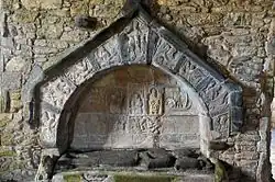 Alasdair Crotach MacLeod is the first McLeod not to be buried on Iona; his tomb on Harris dates from 1528, and is among the finest of this period in Scotland
Credit: Gvdwiele
-
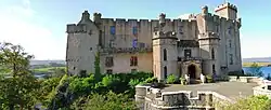
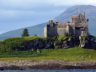 Duart Castle, a 13th-century castle on Mull, the historical seat of Clan Maclean
Credit: Philippe Giabbanelli
-
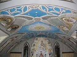 The Italian Chapel on Lamb Holm, Orkney was built from two Nissen huts by Italian prisoners of war during World War 2; the interior frescoes are by Domenico Chiocchetti
Credit: Renata
-
-
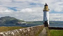 Rubha nan Gall lighthouse, Tobermory, Mull, built in 1857 by David and Thomas Stevenson, with a Caledonian MacBrayne ferry in the background
Credit: Colin
-
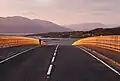 Skye Bridge, opened in 1995; the toll was lifted in 2004
Credit: Gene Selkov
-
-
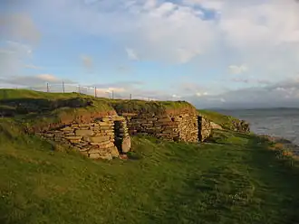 The Neolithic farmstead of Knap of Howar on Papa Westray, Orkney, dates from 3700 BC and might be the oldest surviving stone dwelling in northern Europe
Credit: Me677
-
-
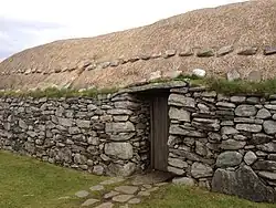 Blackhouses were the traditional form of house across the Hebrides and the Highlands; this example is at Arnol, Lewis
Credit: LornaMCampbell
-
-
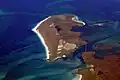
.jpg) Barra Airport is the only one in the world to use a beach as a regular runway
Barra Airport is the only one in the world to use a beach as a regular runwayCredit: Steve Houldsworth
-

-
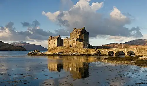 Eilean Donan Castle at the confluence of three sea lochs, Loch Duich, Loch Long and Loch Alsh
Credit: Diliff
-
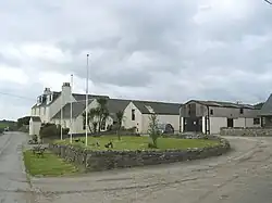
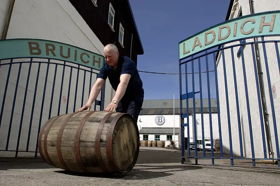 The Bruichladdich distillery, one of eight on Islay; single-malt whisky is a major product of the islands
Credit: Bdcl1881
-
.jpg)
-
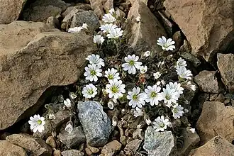 Shetland mouse-ear, a rare plant species unique to Shetland and found only on two serpentine hills in the Keen of Hamar reserve on the island of Unst
Credit: Melvin Grey
-
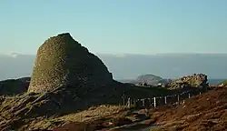 The 1st-century Dun Carloway on Lewis is a well-preserved example of an Iron Age broch, a type of complex Atlantic roundhouse only found in Scotland
Credit: Morris R. Maciver
-
_2.jpg)
-

-
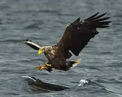 White-tailed eagle fishing off Mull, one of several islands to which the birds have been successfully re-introduced
Credit: Jacob Spinks
-
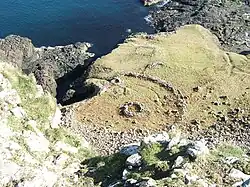 Aerial view of the ruins of a hermitage on Canna
Credit: Peter Van den Bossche
-
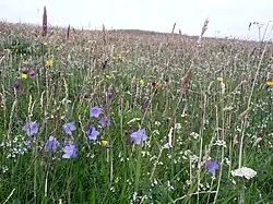 Wildflowers in machair, a coastal dune grassland found in the Outer Hebrides and elsewhere
Credit: Jon Thomson
-
-
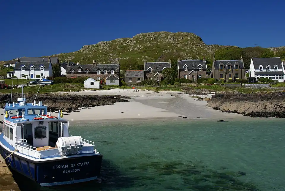 Baile Mòr, the village on Iona
Credit: Clydecoast
-
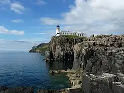 Neist Point Lighthouse on Skye was designed by David Alan Stevenson and dates from 1909
Credit: Lionel Ulmer
Selected island group
The Inner Hebrides (/ˈhɛbrɪdiːz/ HEB-rid-eez; Scottish Gaelic: na h-Eileanan a-staigh, lit. 'the Inner Isles') is an archipelago off the west coast of mainland Scotland, to the south east of the Outer Hebrides. Together these two island chains form the Hebrides, which experience a mild oceanic climate. The Inner Hebrides comprise 35 inhabited islands as well as 44 uninhabited islands with an area greater than 30 hectares (74 acres). Skye, Mull, and Islay are the three largest, and also have the highest populations. The main commercial activities are tourism, crofting, fishing and whisky distilling. In modern times the Inner Hebrides have formed part of two separate local government jurisdictions, one to the north and the other to the south. Together, the islands have an area of about 4,130 km2 (1,594 sq mi), and had a population of 18,948 in 2011. The population density is therefore about 4.6 inhabitants per square kilometre (12 inhabitants per square mile).
There are various important prehistoric structures, many of which pre-date the first written references to the islands by Roman and Greek authors. In the historic period the earliest known settlers were Picts to the north and Gaels in the southern kingdom of Dál Riada prior to the islands becoming part of the Suðreyjar kingdom of the Norse, who ruled for over 400 years until sovereignty was transferred to Scotland by the Treaty of Perth in 1266. Control of the islands was then held by various clan chiefs, principally the MacLeans, MacLeods and MacDonalds. The Highland Clearances of the 19th century had a devastating effect on many communities and it is only in recent years that population levels have ceased to decline.
Sea transport is crucial and a variety of ferry services operate to mainland Scotland and between the islands. The Gaelic language remains strong in some areas; the landscapes have inspired a variety of artists; and there is a diversity of wildlife. (Full article...)
News

- 12 February: The BiFab construction yard at Arnish near Stornoway, Isle of Lewis, is purchased by InfraStrata.
- 11 February: Wild fires occur in Benbecula; and at Achmore and Sildinish in the Isle of Lewis; Horsaclete in Harris; Brevig in Barra; and Eubhal in North Uist.
- 19 January: Barra and Vatersay are put under tier-4 restrictions after an outbreak of Covid-19.
- 18 January: The Shetland Space Centre submits plans for a spaceport on Unst (proposed site pictured), Shetland, including three rocket launch pads.
- 8 January: Distilleries in Orkney and South Uist receive government grants to research ways of reducing their CO2 emissions.
- 4 January: After the UK leaves the European Union, the Northern Celt, an Irish fishing boat based out of Greencastle, County Donegal, is ordered to leave the 12-nautical-mile zone around Rockall by officers of Marine Scotland.
- 1 January: A total of 72 cases of Covid-19 are recorded in an ongoing outbreak in Shetland.
- 9 December: A review by a committee of MSPs into the commissioning and building of two new dual-fuel Caledonian MacBrayne ferries, MV Glen Sannox and "hull 802", criticises CMAL, Transport Scotland and the Scottish government, as well as the ship builders, Ferguson Marine.
- 3 December: North-east Lewis, Sea of the Hebrides and Shiant East Bank are designated Marine Protected Areas, while East Mainland Coast Shetland, Sound of Gigha, Coll and Tiree, Rùm, the west coast of the Outer Hebrides, and the waters off St Kilda and Foula are designated Special Protection Areas.
- 30 November: Michael Russell, MSP for Argyll and Bute, and David Stewart and John Finnie, MSPs for the Highlands and Islands region, will stand down at the 2021 election.
- 17 November: Phytophthora ramorum-infected larch trees in Arran are to be felled over a 543-acre area, to prevent the fungus-like pathogen from spreading.
- 4 November: The Scottish Wildlife Trust objects to a proposed salmon farm in the Marine Protected Area of Wester Ross, near Horse Island, Summer Isles, because of the potential impact on kelp forests and maerl beds.
Selected fauna
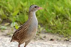
The corn crake, corncrake or landrail (Crex crex) is a bird in the rail family. It breeds in Europe and Asia as far east as western China, and migrates to Africa for the Northern Hemisphere's winter. It is a medium-sized crake with buff- or grey-streaked brownish-black upperparts, chestnut markings on the wings, and blue-grey underparts with rust-coloured and white bars on the flanks and undertail. The strong bill is flesh-toned, the iris is pale brown, and the legs and feet are pale grey. Juveniles are similar in plumage to adults, and downy chicks are black, as with all rails. There are no subspecies, although individuals from the east of the breeding range tend to be slightly paler than their western counterparts. The male's call is a loud krek krek, from which the scientific name is derived. The corn crake is larger than its closest relative, the African crake, which shares its wintering range; that species is also darker-plumaged, and has a plainer face.
The corn crake's breeding habitat is grassland, particularly hayfields, and it uses similar environments on the wintering grounds. This secretive species builds a nest of grass leaves in a hollow in the ground and lays 6–14 cream-coloured eggs which are covered with rufous blotches. These hatch in 19–20 days, and the black precocial chicks fledge after about five weeks. This crake is in steep decline across much of its former breeding range because modern farming practices often destroy nests before breeding is completed. The corn crake is omnivorous but mainly feeds on invertebrates, the occasional small frog or mammal, and plant material including grass seed and cereal grain. Threats include dogs, cats, other introduced and feral mammals, large birds, various parasites and diseases.
Although numbers have declined steeply in western Europe, this bird is classed as least concern on the IUCN Red List because of its huge range and large, apparently stable, populations in Russia and Kazakhstan. Numbers in western China are more significant than previously thought, and conservation measures have facilitated an increased population in some countries which had suffered the greatest losses. Despite its elusive nature, the loud call has ensured the corn crake has been noted in literature, and garnered a range of local and dialect names. (Full article...)
Selected history & culture article
Description of the Western Isles of Scotland is the oldest known account of the Hebrides and the Islands of the Clyde, two chains of islands off the west coast of Scotland. The author was Donald Monro, a clergyman who used the title of "Dean of the Isles" and who lived through the Scottish Reformation. Monro wrote the original manuscript in 1549, although it was not published in any form until 1582 and was not widely available to the public in its original form until 1774. A more complete version, based on a late 17th-century manuscript written by Sir Robert Sibbald, was first published as late as 1961. Monro wrote in Scots and some of the descriptions are difficult for modern readers to render into English. Although Monro was criticised for publishing folklore and for omitting detail about the affairs of the churches in his diocese, Monro's Description is a valuable historical account and has reappeared in part or in whole in numerous publications, remaining one of the most widely quoted publications about the western islands of Scotland.
Monro also wrote a brief description of the five main branches of Clan Donald that existed in his day under the title "The Genealogies Of The Chief Clans Of The Iles", and this work was included when Description was first published as a stand-alone volume in 1805. The Sibbald manuscript also contains details about the "Council of the Isles" that operated from Eilean na Comhairle in Loch Finlaggan on the island of Islay. This is the most detailed extant account of the supreme judiciary body that had existed under the Lordship of the Isles until its demise in the late fifteenth century. (Full article...)
Selected island
Gigha (/ˈɡiːə/ GHEE-ə; Scottish Gaelic: Giogha; Scots: Gigha) or the Isle of Gigha (and formerly Gigha Island) is an island off the west coast of Kintyre in Scotland. The island forms part of Argyll and Bute and has a population of 187 people as of 2022. The climate is mild with higher than average sunshine hours and the soils are fertile. The main settlement is Ardminish.
Gigha has been inhabited continuously since prehistoric times. It may have had an important role during the Kingdom of Dalriada and is the ancestral home of Clan MacNeill. It fell under the control of the Norse and the Lords of the Isles before becoming incorporated into modern Scotland and saw a variety of conflicts during the medieval period.
The population of Gigha peaked at over 700 in the eighteenth century, but during the 20th century the island had numerous owners, which caused various problems in developing the island. At the beginning of the 21st century the population had fallen to 98, however a "community buy-out" in 2002 has transformed the island, which now has a growing population and a variety of new commercial activities to complement farming and tourism.
Attractions on the island include Achamore Gardens and the abundant wildlife, especially seabirds. There have been numerous shipwrecks on the surrounding rocks and skerries. (Full article...)
Did you know?
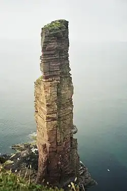
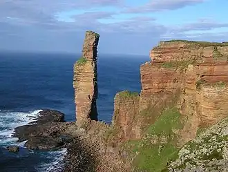
- ... that the geology of the Orkney Islands off the coast of Scotland includes many Devonian era Old Red Sandstone rock formations, such as the Old Man of Hoy (pictured)?
- ... that in 1924 the White Lady, known locally as the "Widden Wife", was shipwrecked in the vicinity of Gossabrough in Scotland?
- ... that Amlaíb Conung was the first King of Dublin?
- ... that nesting is not used by breeding Mute Swans but they do use this thing?
Selected portrait
-
-

-
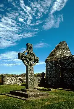 The 8th-century Kildalton Cross, Islay, one of the best-preserved Celtic crosses in Scotland
Credit: Tom Richardson
-
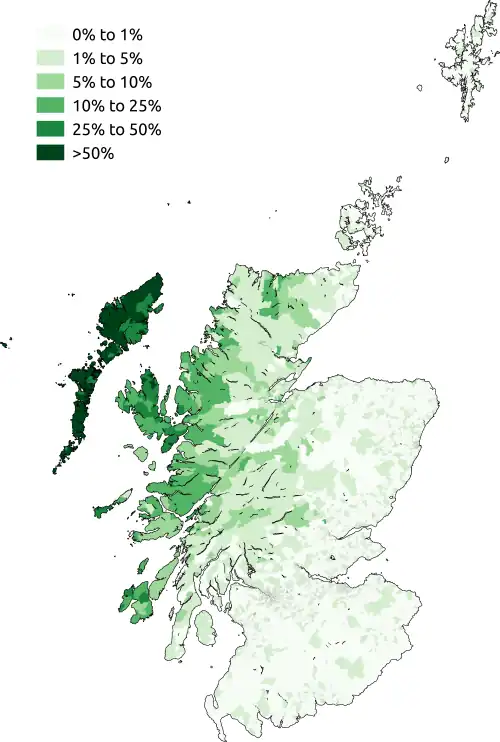 Scottish Gaelic speakers in the 2011 census; the Outer Hebrides, Tiree, Raasay, Skye and Lismore have the highest proportion of speakers
Credit: SkateTier
-
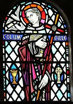 Columba was a 6th-century Irish-born saint who spread Christianity in Scotland and founded Iona Abbey, where he is commemorated in this stained-glass window
Credit: Vegansoldier
-
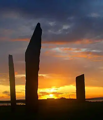 The Standing Stones of Stenness, near Stromness, Orkney, started by 3100 BC and possibly Britain's oldest henge site
Credit: Fantoman400
-
-
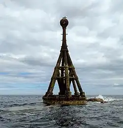 The North Carr Beacon at low tide; the unlit beacon was built between 1813 and 1821 by Robert Stevenson to warn shipping of the North Carr Reef near Fife Ness
Credit: Kathrinpassig
-
-
-
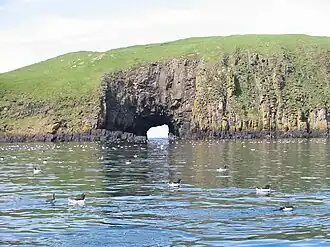
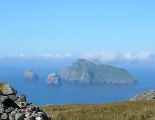
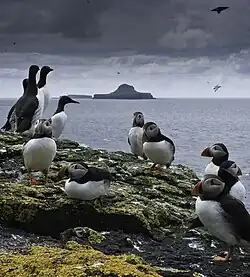 Puffins and guillemots on Lunga in the Treshnish Isles, with Bac Mòr (known as Dutchman's Cap for its distinctive shape) in the background
Credit: Simaron
-
-
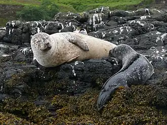
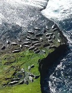 Seals hauled out by Lyrie Geo on Hoy
Credit: Claire Pegrum
Selected geography article
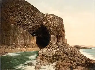
Fingal's Cave is a sea cave on the uninhabited island of Staffa, in the Inner Hebrides of Scotland, known for its natural acoustics. The National Trust for Scotland owns the cave as part of a national nature reserve. It became known as Fingal's Cave after the eponymous hero of an epic poem by 18th-century Scots poet-historian James Macpherson. (Full article...)
Selected biography
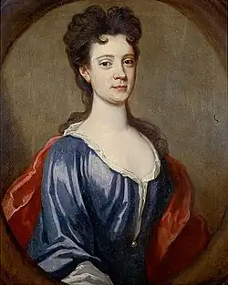
Rachel Chiesley (baptised 4 February 1679 – 12 May 1745), usually known as Lady Grange, was the wife of Lord Grange, a Scottish lawyer with Jacobite sympathies. After 25 years of marriage and nine children, the Granges separated acrimoniously. When Lady Grange produced letters that she claimed were evidence of his treasonable plottings against the Hanoverian government in London, her husband had her kidnapped in 1732. She was incarcerated in various remote locations on the western seaboard of Scotland, including the Monach Isles, Skye and St Kilda.
Lady Grange's father was convicted of murder and she is known to have had a violent temper; initially her absence seems to have caused little comment. News of her plight eventually reached her home town of Edinburgh and an unsuccessful rescue attempt was undertaken by her lawyer, Thomas Hope of Rankeillor. She died in captivity, after being in effect imprisoned for over 13 years. Her life has been remembered in poetry, prose and plays. (Full article...)
Related portals
Selected panorama
-
-
-
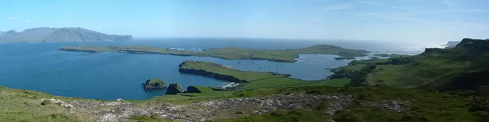
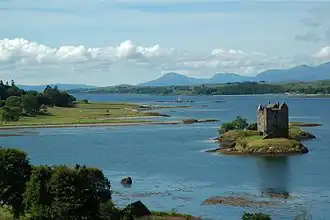
 Eilean Donan
Credit: Stefan Krause
-
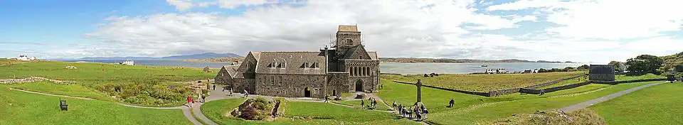 Iona Abbey
Credit: Oliver-Bonjoch
-
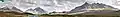
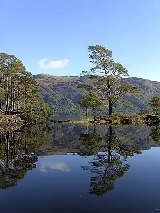
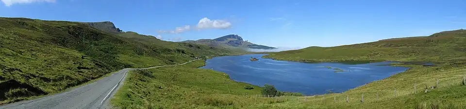
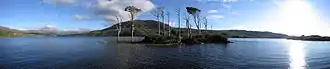 Small freshwater islets on Loch Assynt
Credit: Vincent
-
-
-
-
-
-
-
Topics
|  | ||||||||||||||||
|
| |||||||||||||||||
| |||||||||||||||||
| |||||||||||||||||
| |||||||||||||||||
| |||||||||||||||||
| |||||||||||||||||
| |||||||||||||||||
Categories
The main category is Islands of Scotland, with subcategories

Things you can do
- Add new articles to the project by placing {{WPSI|class=|importance=}} on the talk page
- Add a link to the portal in the "See also" section of relevant articles with {{Portal|Scottish islands}}
- Take requested photographs or create requested pages, including Prehistoric Hebrides, Trialabreac, Dog Isle...
- Expand a Scottish Islands stub into a full article, adding images, citations, references and infoboxes; did you know that if you expand one 5x, you can nominate it for Did You Know?
- Improve one of the highest priority articles, including Mull, Bute, North & South Uist, Columba, Highland Clearances, Sorley MacLean, St Magnus Cathedral...
- Follow these hints to improve a B-class article and nominate it for Good Article

- Suggest articles, pictures, interesting facts, events and news to be featured here on the portal
Wikiproject
Scotland • UK Geography • Islands
Associated Wikimedia
The following Wikimedia Foundation sister projects provide more on this subject:
-
 Commons
Free media repository -
 Wikibooks
Free textbooks and manuals -
 Wikidata
Free knowledge base -
 Wikinews
Free-content news -
 Wikiquote
Collection of quotations -
 Wikisource
Free-content library -
 Wikiversity
Free learning tools -
 Wikivoyage
Free travel guide -
 Wiktionary
Dictionary and thesaurus
-
 List of all portals
 -

-

-

-
-

-

-

-

-

-
 Random portal
 -
 WikiProject Portals