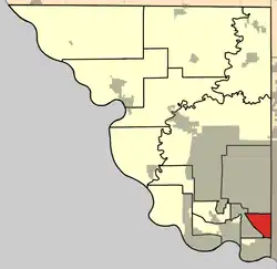
Pawnee Township, Platte County, Missouri
Pawnee Township | |
|---|---|
 | |
| Coordinates: 39°12′44″N 94°37′10″W / 39.2123556°N 94.6194874°W | |
| Country | |
| State | |
| County | Platte |
| Area | |
• Total | 11.2 km2 (4.32 sq mi) |
| • Land | 11.2 km2 (4.31 sq mi) |
| • Water | 0.03 km2 (0.01 sq mi) 0.23% |
| Elevation | 275 m (902 ft) |
| Population | |
• Total | 10,137 |
| • Density | 908.1/km2 (2,352.0/sq mi) |
| FIPS code | 29-16556598[1] |
| GNIS feature ID | 767204[2] |
Pawnee Township is a township in Platte County, Missouri, United States.[2] At the 2020 census, its population was 10,137.[3]
Geography
The area of Pawnee Township is 11.18 square kilometers, of which 11.16 square kilometers are land and 0.02 square kilometers are water.[1]
References
- ^ a b c "MO TIGER County Subdivisions". Missouri Spatial Data Infomration Service. United State Census Bureau. Retrieved April 21, 2025.
- ^ a b c U.S. Geological Survey Geographic Names Information System: Pawnee Township, Platte County, Missouri
- ^ a b "Census 2020 DHC Extract Assistance". Missouri Census Data Center. Retrieved April 21, 2025.
Municipalities and communities of Platte County, Missouri, United States | ||
|---|---|---|
| Cities | 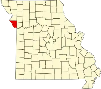 | |
| Villages | ||
| Townships | ||
| CDP | ||
| Other communities | ||
| Footnotes | ‡This populated place also has portions in an adjacent county or counties | |