Pato, Nepal
Pato
पातो | |
|---|---|
 Pato Location in Nepal | |
| Coordinates: 26°31′N 86°37′E / 26.52°N 86.61°E | |
| Country | |
| Zone | Sagarmatha Zone |
| District | Saptari District |
| Population (1991) | |
• Total | 3,520 |
| Time zone | UTC+5:45 (Nepal Time) |
Pato is the headquarter of Dakneshwori Municipality in Saptari District in the Sagarmatha Zone of south-eastern Nepal.[1] At the time of the 1991 Nepal census it had a population of 3520 people living in 705 individual households.[2]
References
- ^ "Google Map location for Pato Village".
- ^ "Nepal Census 2001". Nepal's Village Development Committees. Digital Himalaya. Archived from the original on October 12, 2008. Retrieved 22 November 2008.
| ||
| Municipalities | 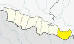 | |
| Rural municipalities | ||