Pansy, Kentucky
Pansy, Kentucky | |
|---|---|
 Pansy  Pansy | |
| Coordinates: 36°46′30″N 83°19′44″W / 36.77500°N 83.32889°W | |
| Country | United States |
| State | Kentucky |
| County | Harlan |
| Elevation | 1,365 ft (416 m) |
| Time zone | UTC-5 (Eastern (EST)) |
| • Summer (DST) | UTC-4 (EDT) |
| ZIP code | 40830[1] |
| Area code | 606 |
| GNIS feature ID | 500147[2] |
Pansy is an unincorporated community in Harlan County, Kentucky, United States. It was also known as Gulston, which had its own post office.[3]
References
- ^ "Gulston ZIP Code". zipdatamaps.com. 2022. Retrieved November 11, 2022.
- ^ U.S. Geological Survey Geographic Names Information System: Pansy, Kentucky
- ^ U.S. Geological Survey Geographic Names Information System: Gulston KY post office
Municipalities and communities of Harlan County, Kentucky, United States | ||
|---|---|---|
| Cities | 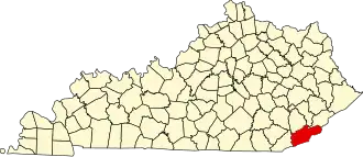 | |
| CDPs | ||
| Other unincorporated communities |
| |
| Ghost towns | ||