Přílepy (Rakovník District)
Přílepy | |
|---|---|
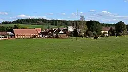 View from the southwest | |
 Přílepy Location in the Czech Republic | |
| Coordinates: 50°7′24″N 13°37′58″E / 50.12333°N 13.63278°E | |
| Country | |
| Region | Central Bohemian |
| District | Rakovník |
| First mentioned | 1399 |
| Area | |
• Total | 6.64 km2 (2.56 sq mi) |
| Elevation | 353 m (1,158 ft) |
| Population (2025-01-01)[1] | |
• Total | 232 |
| • Density | 35/km2 (90/sq mi) |
| Time zone | UTC+1 (CET) |
| • Summer (DST) | UTC+2 (CEST) |
| Postal code | 270 01 |
| Website | www |
Přílepy is a municipality and village in Rakovník District in the Central Bohemian Region of the Czech Republic. It has about 200 inhabitants.
Demographics
| Year | Pop. | ±% |
|---|---|---|
| 1869 | 499 | — |
| 1880 | 535 | +7.2% |
| 1890 | 589 | +10.1% |
| 1900 | 676 | +14.8% |
| 1910 | 681 | +0.7% |
| 1921 | 652 | −4.3% |
| 1930 | 578 | −11.3% |
| 1950 | 366 | −36.7% |
| 1961 | 300 | −18.0% |
| 1970 | 267 | −11.0% |
| 1980 | 223 | −16.5% |
| 1991 | 195 | −12.6% |
| 2001 | 165 | −15.4% |
| 2011 | 194 | +17.6% |
| 2021 | 216 | +11.3% |
| Source: Censuses[2][3] | ||
References
- ^ "Population of Municipalities – 1 January 2025". Czech Statistical Office. 2025-05-16.
- ^ "Historický lexikon obcí České republiky 1869–2011" (in Czech). Czech Statistical Office. 2015-12-21.
- ^ "Population Census 2021: Population by sex". Public Database. Czech Statistical Office. 2021-03-27.
External links
Wikimedia Commons has media related to Přílepy (Rakovník District).