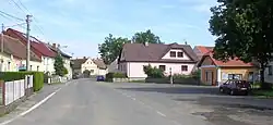
Příčovy
Příčovy | |
|---|---|
 Centre of Příčovy | |
 Flag  Coat of arms | |
 Příčovy Location in the Czech Republic | |
| Coordinates: 49°40′22″N 14°23′23″E / 49.67278°N 14.38972°E | |
| Country | |
| Region | Central Bohemian |
| District | Příbram |
| First mentioned | 1365 |
| Area | |
• Total | 3.09 km2 (1.19 sq mi) |
| Elevation | 360 m (1,180 ft) |
| Population (2025-01-01)[1] | |
• Total | 353 |
| • Density | 110/km2 (300/sq mi) |
| Time zone | UTC+1 (CET) |
| • Summer (DST) | UTC+2 (CEST) |
| Postal code | 264 01 |
| Website | www |
Příčovy is a municipality and village in Příbram District in the Central Bohemian Region of the Czech Republic. It has about 400 inhabitants.
History
The first written mention of Příčovy is from 1365.[2]
Demographics
| Year | Pop. | ±% |
|---|---|---|
| 1869 | 319 | — |
| 1880 | 320 | +0.3% |
| 1890 | 339 | +5.9% |
| 1900 | 285 | −15.9% |
| 1910 | 280 | −1.8% |
| 1921 | 304 | +8.6% |
| 1930 | 316 | +3.9% |
| 1950 | 232 | −26.6% |
| 1961 | 247 | +6.5% |
| 1970 | 227 | −8.1% |
| 1980 | 221 | −2.6% |
| 1991 | 228 | +3.2% |
| 2001 | 250 | +9.6% |
| 2011 | 283 | +13.2% |
| 2021 | 343 | +21.2% |
| Source: Censuses[3][4] | ||
References
- ^ "Population of Municipalities – 1 January 2025". Czech Statistical Office. 2025-05-16.
- ^ "Obec: Historie obce" (in Czech). Obec Příčovy. Retrieved 2023-10-26.
- ^ "Historický lexikon obcí České republiky 1869–2011" (in Czech). Czech Statistical Office. 2015-12-21.
- ^ "Population Census 2021: Population by sex". Public Database. Czech Statistical Office. 2021-03-27.
External links
Wikimedia Commons has media related to Příčovy.