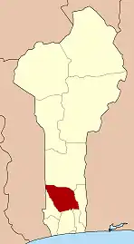
Ouinhi
Ouinhi | |
|---|---|
 Ouinhi Location in Benin | |
| Coordinates: 7°20′N 2°27′E / 7.333°N 2.450°E | |
| Country | |
| Department | Zou Department |
| Area | |
• Total | 186 sq mi (483 km2) |
| Population (2013) | |
• Total | 59,381 |
| Time zone | UTC+1 (WAT) |
Ouinhi [wi.ni] is a town, arrondissement, and commune in the Zou Department of south-western Benin. The commune covers an area of 483 square kilometres and as of 2013 had a population of 59,381 people.[1][2] It is bounded on the north-west by the commune of Zagnanado, south-west by the commune of Zogbodomey, south by the commune of Bonou and east by the commune of Adja-Ouèrè. The commune is divided into arrondissements which include Dasso, Ouinhi, and Tohu, comprising 28 villages.[3]
The arrondissements of Ouinhi and Dasso were struck hard by the 2008 Benin floods in July 2008, tearing down mud and straw homes and infrastructure and polluting rivers.[4]
References
- ^ "Ouinhi". Atlas Monographique des Communes du Benin. Archived from the original on May 9, 2021. Retrieved January 5, 2010.
- ^ "Communes of Benin". Statoids. Retrieved January 5, 2010.
- ^ "Ouinhi". www.ouinhi.communedubenin.org. Archived from the original on April 14, 2009. Retrieved January 5, 2009.
- ^ "BENIN: Half million potential flood victims : WHO". IRIN, UN Office for the Coordination of Humanitarian Affairs. Retrieved January 5, 2010.
External links
7°0′N 2°27′E / 7.000°N 2.450°E