Otofuke, Hokkaido
Otofuke
音更町 | |
|---|---|
Town | |
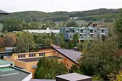 Tokachigawa Onsen | |
 Flag  Seal | |
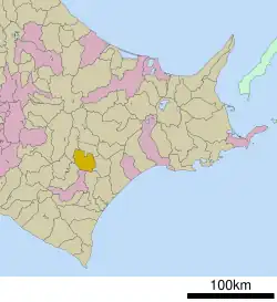 Location of Otofuke in Hokkaido (Tokachi Subprefecture) | |
 Otofuke Location in Japan | |
| Coordinates: 43°0′N 143°12′E / 43.000°N 143.200°E | |
| Country | Japan |
| Region | Hokkaido |
| Prefecture | Hokkaido (Tokachi Subprefecture) |
| District | Katō |
| Area | |
• Total | 466.09 km2 (179.96 sq mi) |
| Population (January 31, 2024) | |
• Total | 42,904 |
| • Density | 92/km2 (240/sq mi) |
| Time zone | UTC+09:00 (JST) |
| Postal code | 080-0198 |
| Climate | Dfb |
| Website | www |

Otofuke (音更町, Otofuke-chō) is a town located in Tokachi Subprefecture, Hokkaido, Japan.
As of January 2024, the town has an estimated population of 42,904 and a density of 92 persons per km2.[1] The total area is 466.09 km2.
Climate
| Climate data for Komaba, Otofuke (1991−2020 normals, extremes 1977−present) | |||||||||||||
|---|---|---|---|---|---|---|---|---|---|---|---|---|---|
| Month | Jan | Feb | Mar | Apr | May | Jun | Jul | Aug | Sep | Oct | Nov | Dec | Year |
| Record high °C (°F) | 6.6 (43.9) |
9.4 (48.9) |
16.6 (61.9) |
29.8 (85.6) |
37.7 (99.9) |
37.8 (100.0) |
36.3 (97.3) |
36.2 (97.2) |
33.1 (91.6) |
26.7 (80.1) |
20.8 (69.4) |
13.1 (55.6) |
37.8 (100.0) |
| Mean daily maximum °C (°F) | −2.3 (27.9) |
−1.2 (29.8) |
3.6 (38.5) |
11.2 (52.2) |
17.4 (63.3) |
20.7 (69.3) |
23.8 (74.8) |
24.9 (76.8) |
21.4 (70.5) |
15.2 (59.4) |
7.5 (45.5) |
0.2 (32.4) |
11.9 (53.4) |
| Daily mean °C (°F) | −8.1 (17.4) |
−7.2 (19.0) |
−1.6 (29.1) |
5.0 (41.0) |
10.9 (51.6) |
14.7 (58.5) |
18.4 (65.1) |
19.6 (67.3) |
16.0 (60.8) |
9.4 (48.9) |
2.6 (36.7) |
−4.6 (23.7) |
6.3 (43.3) |
| Mean daily minimum °C (°F) | −15.6 (3.9) |
−15.2 (4.6) |
−7.8 (18.0) |
−1.0 (30.2) |
4.5 (40.1) |
9.5 (49.1) |
14.1 (57.4) |
15.3 (59.5) |
10.9 (51.6) |
3.5 (38.3) |
−2.5 (27.5) |
−10.7 (12.7) |
0.4 (32.7) |
| Record low °C (°F) | −32.1 (−25.8) |
−30.9 (−23.6) |
−26.9 (−16.4) |
−14.7 (5.5) |
−5.5 (22.1) |
−1.0 (30.2) |
1.9 (35.4) |
3.7 (38.7) |
−0.8 (30.6) |
−5.7 (21.7) |
−18.1 (−0.6) |
−25.9 (−14.6) |
−32.1 (−25.8) |
| Average precipitation mm (inches) | 27.2 (1.07) |
19.9 (0.78) |
32.3 (1.27) |
51.1 (2.01) |
79.0 (3.11) |
78.6 (3.09) |
116.9 (4.60) |
148.9 (5.86) |
131.2 (5.17) |
77.0 (3.03) |
45.1 (1.78) |
38.7 (1.52) |
845.9 (33.30) |
| Average rainy days | 4.9 | 4.3 | 6.1 | 7.7 | 9.5 | 9.8 | 10.8 | 11.9 | 10.9 | 8.7 | 7.3 | 6.2 | 98.1 |
| Mean monthly sunshine hours | 175.7 | 176.5 | 212.0 | 188.4 | 183.3 | 143.1 | 119.2 | 123.9 | 145.8 | 172.4 | 159.5 | 160.9 | 1,956.7 |
| Source 1: JMA[2] | |||||||||||||
| Source 2: JMA[3] | |||||||||||||
Notable persons from Otofuke
References
- ^ "Otofuke (Hokkaidō, Japan) - Population Statistics, Charts, Map, Location, Weather and Web Information". www.citypopulation.de. Retrieved 2023-12-23.
- ^ 観測史上1~10位の値(年間を通じての値). JMA. Retrieved February 22, 2022.
- ^ 気象庁 / 平年値(年・月ごとの値). JMA. Retrieved February 22, 2022.
External links
 Media related to Otofuke, Hokkaidō at Wikimedia Commons
- Official Website (in Japanese)
| ||||||||||||
| ||||||||||||
| ||||||||||||
| ||||||||||||
| ||||||||||||
| ||||||||||||
| ||||||||||||
| ||||||||||||
| ||||||||||||
| ||||||||||||
| ||||||||||||
| ||||||||||||
| ||||||||||||
| ||||||||||||