Nessetal
Nessetal | |
|---|---|
 Coat of arms | |
Location of Nessetal within Gotha district 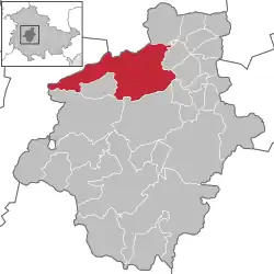 | |
 Nessetal  Nessetal | |
| Coordinates: 51°0′N 10°39′E / 51.000°N 10.650°E | |
| Country | Germany |
| State | Thuringia |
| District | Gotha |
| Subdivisions | 13 |
| Government | |
| • Mayor (2019–25) | Eva-Marie Schuchardt[1] (FW) |
| Area | |
• Total | 91.53 km2 (35.34 sq mi) |
| Elevation | 285 m (935 ft) |
| Population (2024-12-31)[2] | |
• Total | 7,938 |
| • Density | 87/km2 (220/sq mi) |
| Time zone | UTC+01:00 (CET) |
| • Summer (DST) | UTC+02:00 (CEST) |
| Postal codes | 99869 |
| Dialling codes | 03621, 036254, 036255 |
| Vehicle registration | GTH |
| Website | http://gemeinde-nessetal.de/ |
Nessetal (German pronunciation: [ˈnɛsəˌtaːl], lit. 'Nesse Valley') is a municipality in the district of Gotha, in Thuringia, Germany. It was created with effect from 1 January 2019 by the merger of the former municipalities of Ballstädt, Brüheim, Bufleben, Friedrichswerth, Goldbach, Haina, Hochheim, Remstädt, Wangenheim, Warza and Westhausen.[3] These former municipalities are now Ortschaften of the municipality Nessetal.[4] The name refers to the river Nesse.
References
- ^ Gewählte Bürgermeister - aktuelle Landesübersicht, Freistaat Thüringen, accessed 14 July 2021.
- ^ "Bevölkerung der Gemeinden vom Thüringer Landesamt für Statistik" (in German). Thüringer Landesamt für Statistik.
- ^ Gebietsänderungen von Januar bis Dezember 2019, Statistisches Bundesamt
- ^ Hauptsatzung, Gemeinde Nessetal, December 2022.