Nagle Dam
| Nagle Dam | |
|---|---|
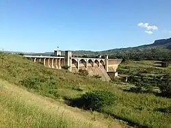 Nagle Dam wall | |
| Official name | Nagle Dam |
| Location | KwaZulu-Natal, South Africa |
| Coordinates | 29°35′40″S 30°38′30″E / 29.59444°S 30.64167°E |
| Opening date | 1950 |
| Operator(s) | Department of Water Affairs and Forestry |
| Dam and spillways | |
| Type of dam | Mass Concrete |
| Impounds | Mgeni River |
| Height | 44.3 metres (145 ft) |
| Length | 393 metres (1,289 ft) |
| Reservoir | |
| Creates | Nagle Dam Reservoir |
| Total capacity | 39,300,000 cubic metres (1.39×10⁹ cu ft) |
| Catchment area | 2545 km2 |
| Surface area | 156.13 hectares (385.8 acres) |
Nagle Dam is a mass concrete type dam located on the Mgeni River, near Cato Ridge, KwaZulu-Natal, South Africa. It was established in 1950 and serves mainly for municipal and industrial purposes. The hazard potential of the dam has been ranked high (3).
-
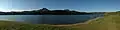 A panorama of Nagle Dam showing the dam wall on the left.
 -
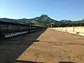 The two-lane road over the dam wall.
See also
References