Mount Monbetsu
| Mount Monbetsu | |
|---|---|
| 紋別岳 | |
 Mount Monbetsu in Spring | |
| Highest point | |
| Elevation | 865.8 m (2,841 ft)[1] |
| Listing | List of mountains and hills of Japan by height |
| Coordinates | 42°47′38″N 141°23′39″E / 42.79389°N 141.39417°E |
| Geography | |
| Location | Hokkaidō, Japan |
| Parent range | Nasu Volcanic Zone |
| Topo map(s) | Geographical Survey Institute (国土地理院, Kokudochiriin) 25000:1 支笏湖温泉, 50000:1 樽前山 |
| Geology | |
| Rock age | Holocene |
| Mountain type | volcanic |
| Volcanic arc | Northeast Japan Arc |
| Climbing | |
| Easiest route | Hiking |
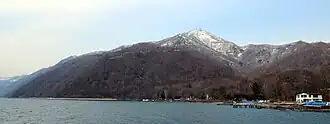
Mount Monbetsu (紋別岳, Mombetsu-dake) is a mountain located in Shikotsu-Toya National Park in Hokkaidō, Japan. It sits on the shore of Lake Shikotsu, a caldera lake. It also hosts a radio relay station.[2]
Climbing Route
There is a road from Lake Shikotsu shore to the top of the mountain.[3]
References
- ^ Geographical Survey Institute website, 25000:1 maps 支笏湖温泉
- ^ Geographical Survey Institute> website, 25000:1 map 支笏湖温泉
- ^ Paul Hunt, Hiking in Japan: An Adventurer's Guide to the Mountain Trails, pg. 181
- Paul Hunt, Hiking in Japan: An Adventurer's Guide to the Mountain Trails, Tokyo, Kodansha International Ltd., 1988. ISBN 0-87011-893-5 and ISBN 4-7700-1393-0 C0075
External links
Wikimedia Commons has media related to Mount Mombetsu (Chitose).