Miston, Tennessee
Miston, Tennessee | |
|---|---|
| Nickname: "Baggett-ville | |
 Miston  Miston | |
| Coordinates: 36°9′53″N 89°29′21″W / 36.16472°N 89.48917°W | |
| Country | United States |
| State | Tennessee |
| County | Dyer |
| Area | |
• Total | 1.39 sq mi (3.59 km2) |
| • Land | 1.39 sq mi (3.59 km2) |
| • Water | 0.00 sq mi (0.00 km2) |
| Elevation | 269 ft (82 m) |
| Population | |
• Total | 77 |
| • Density | 55.52/sq mi (21.44/km2) |
| Time zone | UTC-6 (Central (CST)) |
| • Summer (DST) | UTC-5 (CDT) |
| ZIP Code | 38080 (Ridgely) |
| Area code | 731 |
| FIPS code | 47-49420 |
| GNIS feature ID | 2813078[2] |
Miston is an unincorporated community and census-designated place (CDP) in Dyer County, Tennessee, United States. It was first listed as a CDP prior to the 2020 census.[2]
It is in the northwest part of the county, along Tennessee State Route 103, which leads east 3 miles (5 km) to Bogota and west the same distance to Tennessee State Route 181, less than 2 miles (3 km) east of the Mississippi River. Dyersburg, the county seat, is 13 miles (21 km) southeast of Miston.
Demographics
| Census | Pop. | Note | %± |
|---|---|---|---|
| 2020 | 77 | — | |
| U.S. Decennial Census[4] | |||
Education
The school district is the Dyer County School District.[5] The zoned high school is Dyer County High School in Newbern.
References
- ^ "ArcGIS REST Services Directory". United States Census Bureau. Retrieved October 15, 2022.
- ^ a b c U.S. Geological Survey Geographic Names Information System: Miston, Tennessee
- ^ "Census Population API". United States Census Bureau. Retrieved October 15, 2022.
- ^ "Census of Population and Housing". Census.gov. Retrieved June 4, 2016.
- ^ "2020 CENSUS - SCHOOL DISTRICT REFERENCE MAP: Dyer County, TN" (PDF). U.S. Census Bureau. Retrieved October 6, 2024. - Text list
Municipalities and communities of Dyer County, Tennessee, United States | ||
|---|---|---|
| City | 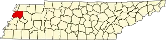 | |
| Towns | ||
| CDPs | ||
| Other communities | ||
| Footnotes | ‡This populated place also has portions in an adjacent county or counties | |