Miloma, Minnesota
Miloma | |
|---|---|
.jpg) Miloma in 2014 | |
 Miloma  Miloma | |
| Coordinates: 43°45′46″N 95°22′06″W / 43.76278°N 95.36833°W | |
| Country | United States |
| State | Minnesota |
| County | Jackson |
| Township | La Crosse |
| Elevation | 1,431 ft (436 m) |
| Time zone | UTC-6 (Central (CST)) |
| • Summer (DST) | UTC-5 (CDT) |
| Area code | 507 |
| GNIS feature ID | 654830[1] |
Miloma is an unincorporated community located in Jackson County, Minnesota, United States at latitude 43.763 and longitude -95.368 (Miloma Panoramio Photos). The elevation is 1,427 feet. Miloma appears on the Heron Lake U.S. Geological Survey Map.[2]
History
Miloma was originally called Prairie Junction, and under the latter name was founded in about 1879 when the railroad was extended to that point.[3] The present name of the community is a double contraction, Milwaukee and Omaha, from the names of two railroads, the Chicago, Milwaukee & Saint Paul and the Chicago, Minneapolis & Omaha.[4][5] A post office was established under the name Prairie Junction in 1881, the name was changed to Miloma in 1906, and the post office closed in 1930.[6]
References
- ^ a b U.S. Geological Survey Geographic Names Information System: Miloma, Minnesota
- ^ "Miloma Populated Place Profile / Jackson County, Minnesota Data".
- ^ Upham, Warren (1920). Minnesota Geographic Names: Their Origin and Historic Significance. Minnesota Historical Society. p. 262.
- ^ Temple, Robert D. Edge Effects: The Border-Name Places, (2nd edition, 2009), iUniverse, ISBN 978-0-595-47758-6, page 324.
- ^ Chicago and North Western Railway Company (1908). A History of the Origin of the Place Names Connected with the Chicago & North Western and Chicago, St. Paul, Minneapolis & Omaha Railways. p. 183.
- ^ "Jackson County". Jim Forte Postal History. Retrieved July 13, 2015.
Municipalities and communities of Jackson County, Minnesota, United States | ||
|---|---|---|
| Cities | 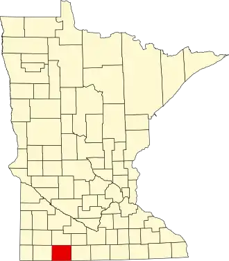 | |
| Townships | ||
| CDP | ||
| Unincorporated communities | ||