Miass (river)
| Miass | |
|---|---|
_-_0_8.jpg) | |
| Location | |
| Country | Russia |
| Physical characteristics | |
| Mouth | Iset |
• coordinates | 56°05′18″N 64°30′00″E / 56.0882°N 64.5°E |
| Length | 658 km (409 mi) |
| Basin size | 21,800 km2 (8,400 sq mi) |
| Basin features | |
| Progression | Iset→ Tobol→ Irtysh→ Ob→ Kara Sea |
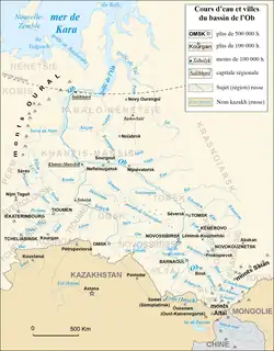
The Miass (Bashkir: Мейәс, Meyäs) is a river on the eastern side of the Ural Mountains in Bashkortostan, Chelyabinsk Oblast and Kurgan Oblast, Russia. It is a right tributary of the Iset, part of the Irtysh basin.[1] It is 149 kilometres (93 mi) long, and has a drainage basin of 13,700 square kilometres (5,300 sq mi).[2] The cities Chelyabinsk and Miass are located on the river.[1][3][4]
References
- ^ a b Миасс (река в Челябинской и Курганской областях), Great Soviet Encyclopedia
- ^ "Река Миасс in the State Water Register of Russia". textual.ru (in Russian).
- ^ "Miass". Encyclopaedia Britannica. Retrieved 19 November 2019.
- ^ "View of the Miass River at Chelyabinsk". World Digital Library. Retrieved 19 November 2019.
External links